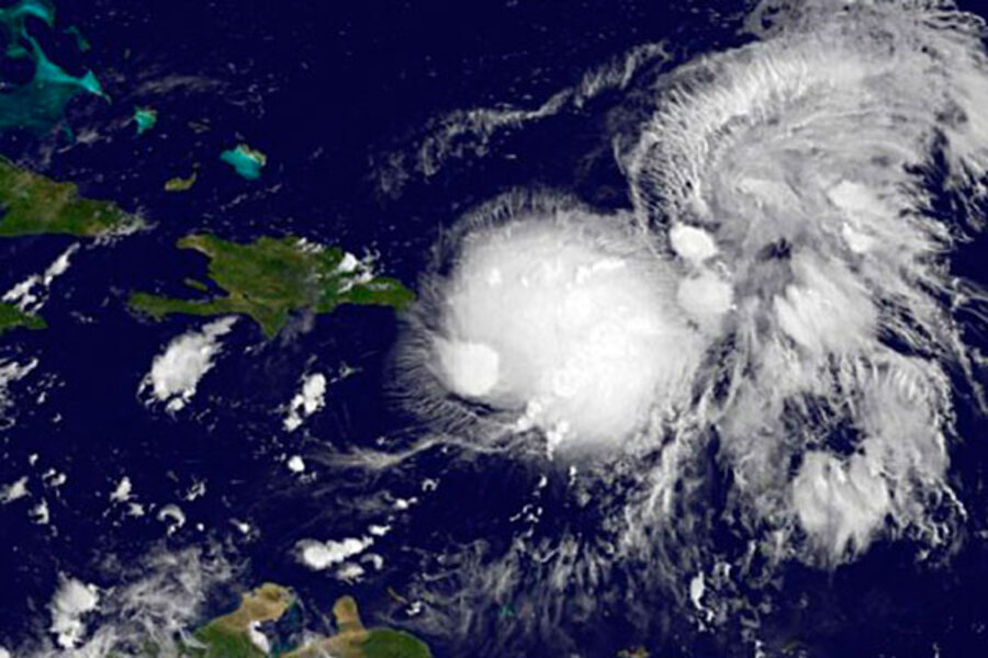
Tropical storm Gabrielle fizzles: Why has hurricane season been so calm?
Loading...
The weather system that had become tropical storm Gabrielle overnight Wednesday has abruptly lost strength and was demoted to tropical-depression status with sustained winds of only 35 miles per hour at 11 a.m. Thursday.
Forecasters at the National Hurricane Center in Miami have lifted tropical-storm watches and warnings they had issued for Puerto Rico. The government of the Dominican Republic has done likewise for areas along its coast that would have been affected.
Forecasters note that Gabrielle encountered one of the banes of tropical cyclones: wind shear, a sudden change in wind speed or direction with altitude. The mountains of Puerto Rico and the Dominican Republic also disrupted the storm, preventing it from becoming more organized.
While forecasters hold out the possibility that the storm could reorganize and strengthen, the official forecast calls for Gabrielle to fully fizzle out within the next 36 hours.
And so goes the 2013 Atlantic hurricane season so far.
The season has produced seven named storms to date – meaning tropical storms or hurricanes. Typically, the seventh named storm doesn't appear until Sept. 14, according to data gathered by the National Hurricane Center.
The number of named storms is on pace to fall within the range several seasonal forecasts have projected. On average, however, the season should have seen its first hurricane by now, and none has emerged. Indeed, the first major hurricane, with maximum sustained winds of 111 miles an hour or more, typically appears around Sept. 4, notes Dennis Feltgen, spokesman for the National Hurricane Center.
If the first hurricane fails to appear until after 8 a.m. Eastern Daylight Time Sept. 11, this will be the most hurricane-free first half of a season since satellites began tracking the storms in 1967, he notes in an e-mail.
One measure of a season's oomph is known as the Accumulated Cyclone Energy – a gauge of the energy tropical cyclones expend one by one and accumulated over a season. Through Sept. 5, this ACE index has reached only 25 percent of the 1981-2010 average, according to the National Hurricane Center data.
Over at the Weather Underground, Jeff Masters, the site's director of meteorology, notes that during the satellite era, only five seasons had comparably low ACE numbers. The energy expended by tropical cyclones fell off during those years either because the ocean temperatures in the main region where the storms first develop was colder than normal or because the seasons fell into El Niño years.
El Niño is part of a cyclical climate pattern in the tropical Pacific, but its extended effects include boosting wind shear in where tropical storms tend to develop in the Atlantic.
This year, El Niño is nowhere to be found and sea-surface temperatures in the main development region for Atlantic tropical cyclones have been running above normal.
Dr. Masters and others look to Africa to help explain the low-intensity season so far. Storms that have developed have been quenched by hot, dry air coming off of the Sahara.
A feature known as the Madden-Julian oscillation also has been at work, meteorologists say. Unlike El Niño and its sibling La Niña, which stick to the Pacific, the Madden-Julian oscillation is well traveled. Its hallmark: broad regions of intense tropical rainfall separated by broad regions of weak rainfall moving in trainlike fashion eastward around the world along the tropics. From the standpoint of someone on the ground watching the pattern, it brings alternating periods of intense and suppressed rainfall that can last from 30 to 60 days.
The periods of heavier rainfall in the main development region for Atlantic storms can encourage tropical-cyclone formation, while the drier phase of the oscillation can suppress tropical formation or inhibit the intensification of existing storms.
At the end of August, Masters notes, the Madden-Julian oscillation train was bringing wetter, more unstable conditions to the region where Atlantic tropical cyclones develop, which could result in greater tropical-storm formation going forward.
For people affected by the storms that have occurred, the season can't be over soon enough. Three tropical storms have struck Mexico on or around the Yucatan peninsula so far this year, and a tropical wave – precursor to a tropical depression – is currently drenching the area. The first three storms killed 14 people.
In June, tropical storm Andrea made landfall along Florida's Gulf Coast and brought much needed rain to the Southeast before it traveled up the Eastern Seaboard.
The peak of the Atlantic hurricane season runs through mid-October, so there's plenty of time for activity to amp up. But if Oct. 8 comes and goes with no hurricanes to date, that will represent a record. The latest "first" hurricane to form in an Atlantic season formed on that date in 1905.


