Gulf oil spill: Louisiana's berm plan bold but full of uncertainty
Loading...
China's Ming Dynasty built the Great Wall to thwart invasion. The French built their Maginot Line. Now Louisiana is gearing up to build offshore embankments of sand as bulwarks against the Gulf oil spill.
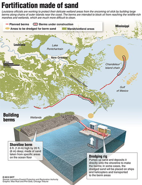
The embankments, or berms, will be placed on the seaward side of several of the state's fragile and vanishing barriers islands, and in some cases form temporary barrier islands, in order to reduce the amount of crude oil invading coastal marshes.
Since the drill-rig blowout April 20, which killed 11 rig workers and destroyed the Deepwater Horizon platform, the well has been spewing between 12,000 and 19,000 barrels a day into the Gulf, according to federal estimates. Scientists outside the government have independently estimated flows several times the officials figure.
IN PICTURES: Gulf oil spill's impact on nature
Late last week, BP installed a containment cap on the wellhead that appears to be capturing about 10,000 barrels a day and sending it to a ship at the surface. But oil is expected to continue leaking from blowout – although at reduced amounts – until BP finishes its two relief wells and can use them to choke the flow.
Oil has expanded its patchy landfall from the western edge of the Mississippi River Delta to beaches along Mississippi, Alabama, and the Florida Panhandle.
During a briefing at the White House today, US Coast Guard Adm. Thad Allen told reporters that he expected the cleanup of oil on the sea surface to continue into the fall, assuming BP's two relief wells are finished in August. But, he added, the amount of time for dealing with "long-term issues of restoring the environment and the habitats and stuff will be years," with oil-fouled wetlands a critical concern.
The berm plan
The berm plan, which President Obama approved last week, initially involves building about 35 miles of berms in six segments – the longest of which, off the Chandeleur Islands east of the Mississippi Delta, stretches 13 miles. In 2005, Hurricane Katrina walloped the string of islands some 50 miles long, turning them into shoals.
The initial berm segments are part of an overall 90-mile effort that the state of Louisiana estimates would cost $350 million to build over a six-to-nine-month period.
The use of berms "has some sound concepts behind it," says Denise Reed, who currently heads the Pontchartrain Institute for Environmental Sciences at the University of New Orleans.
First, she says, it's easier to clean up oil when it's on a sandy beach than it is to remove it from tidal wetlands. Second, well-defined channels between these temporary artificial barrier islands can serve to focus incoming oil in ways that could make it easier to corral with booms and skim.
"One of the reasons it's so easy for the oil to get into the wetlands in Louisiana is that the barrier shoreline is so degraded," Dr. Reed explains.
Yet the technique, which has been applied with some success on much smaller scales, hasn't been used as extensively as it envisioned to be used here. "This is one of the challenges we have: The Louisiana coast huge, and this is a humongous oil spill," she says. "Many of the techniques that have been used in more-modest spill events may have limited application at this scale."
Uncertainties about the effectiveness of berms on this scale are large, she and others note. If the project takes six to nine months to complete, for example, oil could continue to work its way into the wetlands during that period – a situation akin to closing the gate after the dog escapes.
The berms, initially planned to have tops roughly 20 feet wide and six feet above sea level, will be made from the same fine sand that makes up the Gulf's famous beaches.
"We're into the hurricane season, and even heavy surf from a distant tropical storm could tear the berms to shreds," cautions Rob Young, a geoscientist at Western Carolina University in Cullowhee, N.C., who conducts research along the Gulf Coast. Moreover, any oil-laden storm surge could mix oil into the sand as it carries both inland, depositing oil-bearing sediment.
The berms, as well as the sea floor where dredges will scoop up vast quantities of material for the berms, could alter wave and current patterns and velocities in ways that could accelerate the region's already unsustainable rate of coastal erosion, says Gregory Stone, who heads the Coastal Studies Institute at Louisiana State University in Baton Rouge. "We really need to be careful about this," he says.
Scientists suggest an alternative
He and other researchers say they are keenly aware that the BP oil spill constitutes an environmental emergency demanding quick action. But the range of potential unintended consequences gives them pause.
He and colleagues have proposed he use of booms across deep inlets, combined with building up sand dikes from the bottom of those inlets, to buy a one or two weeks' time to conduct the modeling that would help answer some of he questions about unintended consequences.
He says he's aware of the reputation academics have for moving at what can seem like a snail's pace, but the region is loaded with the computer-simulation capabilities to move very quickly in providing a more thorough analysis of the berm plan.
One of the practical questions surrounding the project is the availability of dredges and barges for gathering, moving, and redepositing the sand.
During his press briefing at the White House Monday, Allen noted that the state and BP had worked out funding issues on the project. "There are a couple of barges that are starting to work right away," he said. "But I believe the first place they're going to start working is somewhere around the Chandeleur Islands because the sand source is close enough where they can get to work right away."
West of the Mississippi River, sand will have to come from farther offshore.
"That's a much longer process," he said.
IN PICTURES: Gulf oil spill's impact on nature
Related:


