Is China installing a high-tech radar system in the South China Sea?
Loading...
A US think tank says satellite images show China building a new high-frequency radar system in the Spratly Islands, a move intended to boost their control of the region.
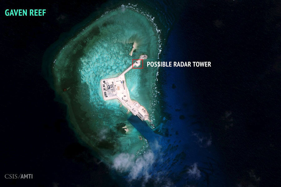
A report released Monday by Washington’s Center for Strategic and International Studies (CSIS), Asian Maritime Transparency Initiative says overhead images of the artificial island above Cuarteron Reef from January to mid-February show two probable radar towers and a number of 65-foot poles.
CSIS warns this could be a significant step in a long-term Chinese plan to assert control over the air and sea lanes of the disputed South China Sea.
If these poles signal a radar installation as the report suggests, the new system “would significantly bolster China’s ability to monitor surface and air traffic across the southern portion of the South China Sea.”
But China has been asserting their control over one of the world’s busiest waterways for decades, saying their claim has been “indisputable” since the Xia and Han dynasties. Neighboring Vietnam, Malaysia, Brunei, the Philippines, and Taiwan all have overlapping claims to the area, where more than $5 trillion in global trade passes every year and likely holds billions of barrels of oil.
And the Asian giant has escalated its claims to the region in the past year, by building seven small new islands and raising fears that China is militarizing the South China Sea.
Just last week, Chinese surface-to-air missiles were found on Woody Island, part of the Paracel Islands, which Beijing claims are simply defense systems to protect their manned islands.
While that move was condemned, “new radar facilities being developed in the Spratleys, on the other hand, could significantly change the operational landscape,” says CSIS.
The radar system will allow Chinese forces to detect both ship and air traffic. China already has significant radar coverage on the mainland and nearby Paracel Islands, explains CSIS, but a radar system on the Cuateron reef is crucial because it would unilaterally access busy straits and channels.
“Improved radar coverage is an important piece of the puzzle – along with improved air defenses and greater reach for Chinese aircraft – toward China’s goals of establishing effective control over the sea and airspace throughout the nine-dash line,” explains CSIS.
The nine-dash line refers to maps used since 1947 by China and Taiwan to claim certain islands in the region.
All three of these capabilities “speak to a long-term anti-access strategy by China – one that would see it establish effective control over the sea and airspace throughout the South China Sea.” CSIS says South China Sea rivals can expect Chinese radar systems at the Gaven, Hughes, and Johnson South reefs as well.
But China says their actions are entirely legal and appropriate.
“Most people in this area recognize that the facilities that China has constructed are primarily for strategic reasons,” Ian Storey, a senior fellow at the Institute of Southeast Asian Studies in Singapore, tells The New York Times. “But that’s how China will spin it.”
In a press conference last week, Foreign Minister Wang Yi said the media should focus on the islands’ lighthouses and weather forecast stations, instead of the country’s “limited and necessary national defense facilities” in the region. Because as the biggest coastal state in the South China Sea, China is “providing goods and services to the international community,” says Mr. Wang.
Despite last week’s missile installations and this week’s radar systems, China says their activities in the South China Sea are exclusively for civilian purposes. And any defensive facilities practiced on the islands are a mere exercise of self-defense as allowed in international law, says Chinese Foreign Ministry spokeswoman Hua Chunying.
The US should stay out of the South China Sea dispute, says Ms. Hua. In fact, she says, constant US close-in patrols of the region are the only reason there has been greater local tension in recent years.
Last month, after a US Navy patrol near Triton island, the US State Department indicated that was exercising its international rights to send ships through the area: “The excessive claims regarding Triton Island are inconsistent with international law as reflected in the Law of the Sea Convention,” said a US Department of Defense statement.
The purpose of US naval patrols in the area, is to assert “freedom of navigation” (FON), “to ensure that US naval, coast guard, and civilian ships, and by extension those of all nations, maintain unrestricted access to their rights at sea," while doing so in such a manner that averts military conflict with China, explain Michael J. Green, Bonnie S. Glaser, and Gregory B. Poling in an article for the CSIS.


