Riding the whirlwind
The Monitor's intrepid science writer rode with the storm-chasers who help federal forecasters warn those in twisters' paths.

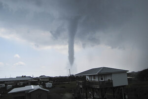
In this photo from NOAA, what is believed to be a tornado is seen touching down in Grand Isle, La., Wednesday, May 9.
Courtesy of Tim Osborn/NOAA/AP
Tornado survivors often supply similar accounts of their ordeals. They describe the horrifying sound, like a train much too close, and the disheartening sights that reveal themselves once the fury has subsided. They reach for war images in trying to describe the devastation: It may look as though a bomb has gone off. Many marvel at the vagaries of swiveling twisters: One neighborhood is leveled; another is left with not a shingle askew.
Often those who ride out these most American of severe-weather occurrences also remark on the kindness of others in helping them, quite literally, to pick up the pieces. That they can count on.
But easy predictability is not a characteristic of tornadoes. These Great Plains-stalking storms form suddenly, sometimes in bunches, lurching down from supercells like the hammers of Thor.
The people who study them – and whose important work ultimately pays off in ways ranging from improved storm-warning times to better home-building techniques – have their own lexicon. They talk about "wall clouds" and "hook echoes." And because they can learn just so much by peering at a computer monitor, they go out into the field. They go in pursuit.
For this week's cover story, veteran Monitor science writer Pete Spotts immersed himself in the highly collaborative culture of responsible funnel hunters, riding with Kiel Ortega from NOAA's National Severe Storms Laboratory in Norman, Okla.
"It's far more responsible than some of the storm chasing you see on TV," Pete says, describing a kind of informal hierarchy among those who essentially crowdsource the detailed information that becomes the basis of high-stakes weather forecasting.
There are enthusiastic people with laptops, cellphones with signal amplifiers, GPS locators cross-linked with those of other chasers. The coordinated effort of this army feeds a website. Most are not mere thrill seekers setting out for YouTube fame, though as with anything, there is a fringe element.
"There are some people chasing who have official-looking stuff on their cars, but are not tied to any official group," one source told Pete. But you need to have taken a basic online weather course in order to upload to the chaser website that federal forecasters monitor.
With a college undergraduate at the wheel, and Mr. Ortega's colleague Kristen Calhoun helping with observations and strategy, Pete spent a recent Saturday in a Honda CR-V roaming around a very active slice of "Tornado Alley."
The group intercepted four storms. Three of them fizzled. Then the fourth, the last in a chain, "began to do interesting things," Pete recalls. Was that a wall cloud forming?
"It ended up being the one that dropped down a dozen twisters, and sent one through Wichita," Pete says. (The event in Kansas was nonfatal.) Pete and his team chased the storm across the state line, watching it backlit by lightning before breaking off their chase at around 10 p.m. and swinging back toward Norman.
"On the prairie, they can be spectacular to watch," Pete says of the powerful storms. "Out there it seems as though the greatest risk is the driving of other storm chasers. Obviously, tornadoes lose their luster when they threaten cities and towns."
• Clayton Collins is the editor of the weekly edition. Monitor editor John Yemma returns to this space next week.

