How an Alaskan front became the Midwest megastorm
Meteorologists continue to marvel at the megastorm that blew through the Midwest Tuesday. Several peculiar weather events combined to make the storm historic.

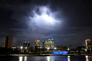
Lightning illuminates storm clouds north of downtown Birmingham, Ala., as the tail of the severe weather that raked the Midwest passed through the South Tuesday.
Mark Almond/The Birmingham News/AP
The US heartland hasn't seen a storm like this week's record-breaker since the Great Ohio Blizzard of January 1978, and residents probably hope they see nothing like it soon.
The mighty low-pressure system that brought heavy rain, high winds, and tornadoes to the central US is slowly pirouetting its way through Ontario toward Canada's eastern Maritime Provinces.
In its wake, residents across the Dakotas are digging out from heavy snow and folks farther east and south are coping with downed tree limbs, power outages, and damaged homes.
Weather forecasters are marveling at the powerful system.
"It's a fascinating storm," says David Imy, a forecaster with the National Oceanic and Atmospheric Administration's Storm Prediction Center (SPC) in Norman, Okla. It spawned 24 tornadoes from Wisconsin to North Carolina. Forecast offices in the region tallied nearly 300 reports of wind damage.
Federal forecasters note that the atmospheric pressures at the storm's center reached a record low for a continental storm – dropping to 28.24 inches of mercury Tuesday. It's a level typically seen in major hurricanes.
Autumn often brings a second bout of severe weather, a kind of mirror image to severe storms in spring and early summer in the heartland, Mr. Imy explains.
But this fall so far has been warmer than normal over much of the country. A dearth of invading cold fronts, which dry out the air, has allowed the atmosphere to retain more moisture, providing extra fuel that helped build this system into a megastorm.
The beginnings of a megastorm
Forecasters first took note of the storm heading into last weekend as the large low-pressure system moved into the Pacific Northwest from the Gulf of Alaska, Mr. Imy says. It brought high winds and heavy snows to the mountains there.
By Monday, it was doing the same over the central Rockies and into Colorado. At the time, however, it had yet to draw on significant amounts of moist air available from the Gulf of Mexico.
But as forecasters looked ahead, it appeared that there was a good chance the storm would begin to sweep additional moisture up from the Gulf, particularly as it approached the Mississippi River Valley.
By Tuesday, the storm had evolved to a point where SPC forecasters suspected it could deliver a serious meteorological blow to regions in its path. At midnight Tuesday, they posted warnings that the storm had a high potential for triggering tornadoes and damaging winds.
At the storm's height Tuesday, the comma-like tail arching from the storm's broad cloud mass along the US-Canadian border to the Rio Grande River in southern Texas spanned some 800 miles. The tail, the battle line between warm moist air to the east and colder air to the west, has continued to move east with the storm.
This advancing squall line has prompted forecasters to post tornado watches through 8:00 to 9:00 p.m. Eastern time Wedensday from east-central Mississippi across a swath of the southeast and up to the southern tip of New Jersey.
Wind speeds up to 90 m.p.h.
The SPC's Imy explains that the storm's broad expanse kept sustained winds below hurricane speeds, despite hurricane-like low pressures. Still, gusts ranged from 45 m.p.h. in Hastings, Neb., to 77 m.p.h. in Greenfield, Ind.
The winds hit higher speeds in the squall line – as much as 80 and 90 m.p.h., Imy says. Those winds represented a one-two punch: Already strong down drafts transported some of the strong jet-stream winds to the surface, he says.
Lurking in the background: La Niña, one half of a major climate cycle in the tropical Pacific every three to seven years that affects broad circulation patterns in the atmosphere over much of the globe. For the US, a La Niña event tends to keep warmth and moisture in the central part of the country in the fall and winter.
"We could be kind of active the next month," Imy says of additional fall storms.
