Winter's freezing, so what's with Arctic sea ice?
An unusually warm January has limited the return of Arctic sea ice, whose extent set a record low for the month. The ice's ability to reflect sunlight back into space has a significant influence on climate worldwide.

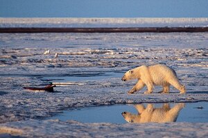
A polar bear in the Arctic National Wildlife Refuge in Alaska. If the world dramatically changes its steadily increasing emissions of greenhouse gases, global warming can be slowed enough to prevent a total loss of critical summer sea ice for the polar bears, according to a study in the journal Nature last December.
Subhankar Banerjee/AP/File
Much of the US continues to dig out from record snows and shivers from unusually frigid temperatures. But at the top of the world, an unusually warm January has limited the return of Arctic sea ice, whose extent set a record low for the month, according to the National Snow and Ice Data Center in Boulder, Colo.
Indeed, through January, the season's sea-ice return is closely tracking that of ice during the winter of 2006-2007, according to data the center released earlier this week. The below average return of sea ice then contributed to a record low summer-ice extent during the 2007 melt season.
Climate scientists keep close tabs on the Arctic Ocean's ice – particularly during the sun-drenched melt season – because the ice's ability to reflect sunlight back into space has a significant influence on climate worldwide, more so than Antarctica's sea ice, researchers say.
Top 10 global weather events of 2010
Antarctica's sea ice builds quickly during its winter months and extends over large areas of the ocean surrounding the continent, even as the Arctic Ocean's ice retreats.
But Antarctic sea ice shrinks quickly during its melt season, covering only a tiny fraction of the area it spans during the Austral winter, when it's dark. Arctic Ocean sea ice, by contrast, typically extends over much of the Arctic Ocean, even through the melt season, reflecting sunlight and keeping the region cooler than it otherwise would be.
In January, Arctic sea ice covered 13.6 million square miles of ocean, nearly 20,000 square miles below the previous record low in January 2006 and some 490,000 square miles below the 1979-2000 average.
The drivers for January's record low extent, according to the National Snow and Ice Data Center, included a natural climate pattern known as the Arctic Oscillation, as well as residual heat from the Arctic Ocean, captured and retained during the previous melt season.
When the Arctic Oscillation is in a negative phase, wind patterns change in ways that can permit frigid Arctic air to plunge farther south than usual, accounting for below-normal winter temperatures in much of the US in January, including the South.
At the same time however, Arctic temperatures can run above normal during a negative phase. In January, much of the region experienced temperatures between 4 and 11 degrees Fahrenheit above normal, according to the NSIDC.
As February began the oscillation switched to a positive phase, which could speed ice growth for a period, according to the center.
But the prognosis for ice extent during the upcoming melt season isn't good, according to Mark Serreze, who heads the NSIDC.
Even if the ice were to reach a winter expanse nearer normal, "a lot of that ice is thin, first-year stuff, and it's going to tend to melt out easily" come spring, he says.
Indeed, he adds, the thickness of the ice heading into the melt season is a bigger factor than overall winter extent in determining how severe the spring melt-back is likely to be. Researchers over the past several years have documented a decline in older ice and an increase in thinner ice at the start of the melt season.
"We know right now, that we'll be continuing that pattern" heading into the 2011 melt season, he says.
Nor is he looking for help from the Arctic Oscillation. While the strong negative this winter has kept things relatively toasty during an Arctic winter, it historically has tended to set up conditions that kept ice in the Arctic Ocean basin during the melt season. Winds also would spread the ice out, allowing more ice to grow in the wide cracks between floes.
Until last year, that is.
In a paper published Jan. 29 in the journal Geophysical Research Letters, a team led by Julienne Stroeve, also with the NSIDC, found that last winter's strongly negative Arctic Oscillation had its own unusual circulation pattern, which ultimately provided no help in retaining ice during the 2010 melt season. Instead, last melt season registered the third lowest summer-ice extent on record.
"It appears we're entering a new regime where old rules don't apply anyone," he says.
Since satellites began tracking Arctic sea-ice extend continuously in 1979, the maximum and minimum sea-ice extents have been steadily shrinking, when stacked against their 1979 to 2000 averages.
Researchers attribute the long-term to a self-reinforcing trend, or feedback, associated with global warming. As ice cover shrinks during the melt season, more of the ocean, darker than the ice, is exposed to absorb sunlight and retain it as heat. As fall arrives, the ocean releases the heat, slowing the return of sea ice.
Indeed, researchers are exploring the possibility that increases in ice loss could be driving the Arctic Oscillation into a negative phase more often than not. The jury is still out, Serreze says.
