Forecast: Seattle weather could stay eventful in next three months
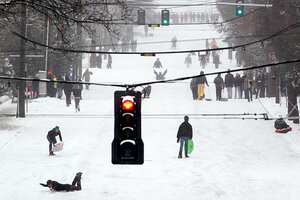
Forecasters looking at temperature and precipitation trends are calling for cooler and wetter conditions than normal in the Pacific Northwest. Seattle weather this week has consisted of snow and ice storms.

Sledders, skiers, snowboarders and pedestrians take over a snow-covered street in the Queen Anne neighborhood of Seattle on Wednesday. Seattle weather this week has consisted of snow and ice storms.
Elaine Thompson/AP
If this week's snow and ice storms have left you sleepless in Seattle, break out the waders, if not the snowshoes.
Federal forecasters looking at temperature and precipitation trends over the next three months are calling for cooler and wetter conditions than normal in the Pacific Northwest.
Indeed, over the next 14 days, the western United States is expected to be the country's ground zero for a range of hazardous conditions – from heavy snow in the northern Rockies to high winds throughout most of the region to heavy rains for the Pacific Coast, from just north of San Luis Obispo, Calif., to Seattle and beyond.
For the rest of the country, up to two-thirds of the Lower 48, from Arizona to the East Coast, is expected to be warmer than normal. Much of the Upper Midwest and Ohio River Valley is in the wetter-then-normal zone, while drier than normal remains the order of the season for the southern tier – already experiencing severe, prolonged drought.
Does this have a vaguely familiar ring to it? It's a general pattern the country experienced last winter, as La Niña also made its presence felt. La Niña is the cool half of a periodic swing in ocean-surface temperatures across the tropical Pacific.
While the effects of La Niña, and its warm alter ego El Niño, are most acute in the tropics, these changes affect atmospheric circulation patterns at higher latitudes as well.
La Niña tends to force the average track that storms take across North America farther north than usual, drying out the southern US while dumping rain and snow across the Pacific Northwest, Midwest, and Northeast.
Currently, forecast models indicate La Niña will weaken "as we get into the middle of spring," notes Ed O'Lenic, who heads the operations branch at the National Oceanic and Atmospheric Administration's Climate Prediction Center in Camp Springs, Md.
Those forecasts came as NOAA unveiled its initial weather-and-climate year in review for 2011.
Record tornado outbreaks last spring; searing summer temperatures and withering drought in Texas, New Mexico, Oklahoma, and Louisiana; and torrential downpours from hurricane Irene and tropical storm Lee helped rack up more than $55 billion in damage in 2011.
"2011 was an extraordinary year," said Kathryn Sullivan, assistant secretary of Commerce for environmental prediction, at a briefing Thursday. Moreover, tropical storm Lee and a severe-weather outbreak in July in the Rockies and Upper Plains have only recently been added to the list of events that inflicted more than $1 billion in damage last year.
Officials are looking at last Halloween's snowstorm in the Northeast to see if it also needs to be added, she said.
While NOAA officials are reluctant to attribute the various outbreaks of severe weather in 2011 to global warming, longer-term temperature patterns are emerging that they say are consistent with model projections of a warming climate as carbon-dioxide emissions from human industrial activities and land-use changes increase.
Last year marked the 15th consecutive year with a national average temperature for the year above normal, with much of the warmth coming from increases in nighttime low temperatures.
"That's consistent with the increase in temperatures" globally, said Thomas Karl, who heads NOAA's National Climatic Data Center (NCDC) in Asheville, N.C.
The data also show that the proportion of the country affected either by extremely dry or extremely wet conditions in a given year has expanded.
Since a 20th-century low of about 3 percent in 1970, the extent of the country affected each year by either of these two conditions has climbed unsteadily to a record 58 percent last year. The average for the 20th century is just over 20 percent.
Globally, 2011 tied 2008 as the second coolest year so far this century, which still boasts nine of the 10 warmest years on record – including the warmest (2005 and 2010). But measured against the 20th-century records, 2011 would find itself in a tie as the second-warmest year on record. It ties for the 11th warmest since 1880.
Climate researchers have noted that a generally warming climate will still have its natural swings, such as the El Niño and La Niña cycles. But their effects would be superimposed over the longer-term warming trend.
That pattern emerges in NOAA's data tracking temperatures during El Niño and La Niña years, as well as during what Deke Arndt, who heads the NCDC's climate monitoring branch, dubs the "La Nada" years, when conditions are neutral.
Since the 1980s, El Niño years have undergone their own warming trend, as have La Niña years.
As the US heads into midwinter, at least one climate factor has kept last year's deep chill from the Deep South again. The Arctic Oscillation, another kind of natural climate swing, has been in a strong positive phase so far – generating pole-circling winds strong enough to keep cold arctic air from plunging deep into the continental interior.
For now, forecasters expect the Arctic Oscillation to remain positive, bringing temperatures a bit warmer than normal to the north-central US, says Mr. O'Lenic.

