Earth permanently deformed by big quakes? Measurements in Chile challenge established theory.
Earth permanently deformed: New research suggests that large-scale temblors can leave permanent scars on the crust of our planet.

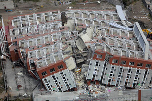
A collapsed building lays in ruins after an earthquake in Concepcion, Chile, in March 2010.
Natacha Pisarenko/AP/File
Large earthquakes can deform the earth's crust permanently, a study of major quakes in northern Chile over the past million years suggests.
This finding challenges a longstanding theory in geology that seeks to explain how energy is spread during earthquakes. First posited in 1910 by Johns Hopkins geologist Harry Fielding Reid after he observed the displacement of the ground following San Francisco's devastating 1906 earthquake, the elastic rebound theory holds that rock on either side of a fault slowly deforms over time, until it suddenly snaps back into its original shape, causing the quake. Reid's theory was the first to satisfactorily account for earthquakes, and has ben supported by many GPS measurements, among other evidence.
But a study of major earthquakes in Chile complicates the picture. A team led by Cornell University geologist Richard Allmendinger, who examined temblors of magnitude 7 or greater in Chile's Atacama Desert, found permanent deformations in the Earth's crust.
"My graduate students and I originally went to northern Chile to study other features," Allmendinger told LiveScience writer Charles Q. Choi. "While we were there, our Chilean colleague, Professor Gabriel González of the Universidad Católica del Norte, took us to a region where these cracks were particularly well-exposed."
"I still remember feeling blown away — never seen anything like them in my 40 years as a geologist — and also perplexed," Allmendinger said. "What were these features and how did they form? Scientists hate leaving things like this unexplained, so it kept bouncing around in my mind."
The Atacama Desert has been rocked by some of the largest earthquakes over the past 100 years, including a 8.1 Richter earthquake in 1995 and a 7.7 Richter earthquake in 2007.
In a paper published by the journal Nature Geoscience, Allmendinger said that up to 10 percent of the horizontal deformations created during the quakes, recorded by GPS data and previously assumed to be recoverable, are permanent. The deformations in the crust of the Atacama Desert measuring millimeters to meters large were generated by between 2,000 and 9,000 earthquakes during the past 800,000 to 1 million years.
The hyperarid Atacama Desert, Allmendinger said, may be the only place in the world where such permanent deformation can be preserved and identified.
"It is only in a place like the Atacama Desert that these cracks can be observed — in all other places, surface processes erase them within days or weeks of their formation, but in the Atacama, they are preserved for millions of years," Allmendinger told LiveScience. "We have every reason to believe that our results would be applicable to other areas, but is simply not preserved for study the way that it is in the Atacama Desert."
Prior to Allmendinger's research, a study by the Institute of Geomatics – Research Centre of the Polytechnic University of Catalonia (UPC) and the Government of Catalonia showed that the 9.0 magnitude Japan earthquake in 2011 caused a permanent ground deformation in the city of Sendai. The deformation was estimated 1.69 meters.
The 2004 temblor in North Sumatra, Indonesia which left 227,898 people dead or missing, also left permanent marks on the Earth. The 8.7 Richter disaster resulted in permanent displacements covering a vast region around the epicenter exceeding 40 million square miles, according to one study.

