Curiosity Mars rover now driving itself, says NASA
NASA's Curiosity Mars rover, which has been exploring the Red Planet for just over a year, is now on 'autonav' mode, making its way across a dip in the Martian ground.

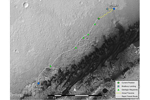
NASA's Mars rover Curiosity left the "Glenelg" area on July 4, 2013, for the base of Mount Sharp. As of Aug. 27, 2013, Curiosity had driven about 0.86 mile since leaving Glenelg, with about 4.46 miles remaining to get to the entry point.
NASA/JPL-Caltech/Univ. of Arizona
After obeying orders on the Red Planet for more than a year, NASA's Mars rover Curiosity has finally gotten its first taste of freedom.
The 1-ton Curiosity rover used autonomous navigation for the first time on Tuesday (Aug. 27), driving itself onto a patch of ground that its handlers had not vetted in advance. The robot will likely employ this "autonav" capability more and more as it continues the long trek toward the base of Mars' huge Mount Sharp, NASA officials said.
In autonav mode, Curiosity analyzes photos it takes during a drive to map out a safe route forward. The car-size rover used this ability on Tuesday to find its way across a small depression whose fine-scale features were hidden from Curiosity's previous location. [Curiosity's 7 Biggest Achievements (So Far)]
"We could see the area before the dip, and we told the rover where to drive on that part," rover driver John Wright, of NASA's Jet Propulsion Laboratory in Pasadena, Calif, said in a statement. "We could see the ground on the other side, where we designated a point for the rover to end the drive, but Curiosity figured out for herself how to drive the uncharted part in between."
Curiosity drove about 33 feet (10 meters) in autonav mode Tuesday, out of a total driving distance of 141 feet (43 m) for the day.
Curiosity landed inside the 96-mile-wide (154 kilometers) Gale Crater on Aug. 5, 2012 to determine if Mars could ever have supported microbial life. The rover has already checked off that primary mission goal, determining in March that an area called Yellowknife Bay was indeed habitable billions of years ago.
The rover stuck close to its landing site for nearly a year after touching down. But in early July, Curiosity set out for the 3.4-mile-high (5.5 km) Mount Sharp, whose many layers hold a record of the Red Planet's changing environmental history over time.
Curiosity has now covered 0.86 miles (1.39 km) on this trek, with about 4.46 miles (7.18 km) left to go along a provisional path mapped out using orbital observations, NASA officials said. The actual driving route may be longer or shorter, since it will be based on images Curiosity captures along the way.
The mission team also plans to stop at a few places along the way to do some science work. The first of these "waypoints" lies about 0.31 miles (0.5 km) from Curiosity's current location.
"Each waypoint represents an opportunity for Curiosity to pause during its long journey to Mount Sharp and study features of local interest," Curiosity chief scientist John Grotzinger, of the California Institute of Technology in Pasadena, said in a statement.
"These features are geologically interesting, based on HiRISE images, and they lie very close to the path that provides the most expeditious route to the base of Mount Sharp," Grotzinger added, referring to the HiRISE instrument aboard NASA's Mars Reconnaissance Orbiter. "We'll study each for several sols [Martian days], perhaps selecting one for drilling if it looks sufficiently interesting."
Follow Mike Wall on Twitter @michaeldwall and Google+. Follow us @Spacedotcom, Facebook or Google+. Originally published on SPACE.com.
- Amazing Mars Rover Curiosity's Martian Views (Latest Photos)
- The Boldest Mars Missions in History
- A 'Curiosity' Quiz: How Well Do You Know NASA's Newest Mars Rover?
Copyright 2013 SPACE.com, a TechMediaNetwork company. All rights reserved. This material may not be published, broadcast, rewritten or redistributed.

