Why is NASA flying planes over Alaska?
A trio of NASA missions are using turboprop aircraft to examine changes in Arctic sea ice, glaciers, and permafrost.

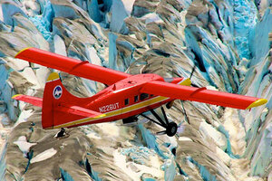
Scientists from the University of Alaska, Fairbanks, survey Alaska glaciers in a DHC-3 Otter aircraft as part of NASA's Operation IceBridge.
Chris Larsen, University of Alaska, Fairbanks
A speedy trip across Alaska's vast, roadless tundra and tall mountains requires travel by air. The state has more private planes for each of its residents than any other state in the union.
Three NASA science missions traveled the Alaskan way this summer, soaring above Arctic sea ice, piloting over permafrost and gliding past mountain glaciers. The projects are tracking changes in the rapidly warming Arctic that are best monitored by air.
"We can't do everything with satellites," Tom Wagner, NASA's cryospheric sciences program manager, said during a media teleconference Tuesday (Sept. 16).
The Carbon in Arctic Reservoirs Vulnerability Experiment (CARVE) surveys permafrost two weeks out of every month in a C-23 Sherpa aircraft fitted with instruments that measure greenhouse gases. Huge areas of Alaska, Canada and northern Russia have permafrost, soil that remains frozen year round. But permafrost soils are warming even faster than Arctic air temperatures, increasing as much as 2.7 to 4.5 degrees Fahrenheit (1.5 to 2.5 degrees Celsius) in the past 30 years. As the soil thaws, carbon stored on ice for centuries escapes. [On Ice: Stunning Images of Canadian Arctic]
Permafrost holds 1,000 billion metric tons of carbon, said Chip Miller, CARVE principal investigator at NASA's Jet Propulsion Laboratory in Pasadena, California. And that carbon, once freed from the soil, can transform into climate-warming gases, such as methane and carbon dioxide. Scientists are tracking whether atmospheric levels of these gases are higher above permafrost than in other areas.
The interplay between melting ice and the atmosphere is also a focus for the new Arctic Radiation IceBridge Sea and Ice Experiment (ARISE). Launched this summer, the experiment measures how clouds help or hinder global warming above Arctic sea ice. Clouds reflect sunlight, cooling the Earth, but they can also trap heat radiating from the planet, boosting surface temperatures, said Bill Smith, principal investigator for ARISE at NASA's Langley Research Center in Hampton, Virginia. ARISE scientists plan to untangle this tricky relationship.
And as the researchers scan clouds and ice offshore Alaska, flying aboard a NASA C-130 Hercules aircraft, the agency's satellites will also spy on the same spots. The simultaneous collection of data will help improve Arctic satellite monitoring, Smith said.
Finally, NASA's long-running Operation IceBridge is monitoring the health of Alaska's glaciers. Twice a year, before and after the summer melt season, researchers scan up to 140 mountain glaciers with a plane-mounted laser altimeter. Two decades of data indicate glaciers in southern Alaska are losing ice, though not as rapidly as in West Antarctica, said Evan Burgess, a University of Alaska Fairbanks glaciologist and member of the IceBridge Alaska team.
In this state, mountain glaciers have retreated so far inland that little ice is left to cleave off into the water, he said. Alaska's glacial ice loss now comes from thinning, not from icebergs calving at the front of the glacier. "Most of their potential for catastrophic ice mass loss has already run its course," Burgess said.
Operation IceBridge is in its sixth year of monitoring changes in polar ice. The airborne mission fills a gap between two ice-tracking satellites.
Email Becky Oskin or follow her @beckyoskin. Follow us @livescience, Facebook & Google+. Original article on Live Science.
- In Images: IceBridge Investigates Antarctica
- NASA Quickly Preps Aircraft For Arctic Warming Research | Video
- Get a Rare Glimpse of Remote Alaska
Copyright 2014 LiveScience, a TechMediaNetwork company. All rights reserved. This material may not be published, broadcast, rewritten or redistributed.

