How eight microsatellites could improve hurricane forecasts
The suitcase-sized satellites began moving off assembly tables earlier this month and are designed to estimate wind speeds in the core of a hurricane.

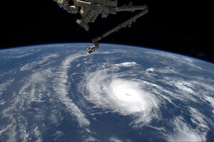
Hurricane Danny, the first hurricane of the 2015 Atlantic season, is seen in this picture by NASA astronaut Scott Kelly taken from the International Space Station August 20, 2015.
REUTERS/NASA/Scott Kelly/Handout
A handful of tiny satellites, each weighing as much as the average 7-year-old, is raising expectations for big improvements in hurricane-intensity forecasts.
The project, dubbed CYGNSS, involves eight microsatellites, the gnats of the satellite business. Each is designed to provide more-accurate estimates of the strength of surface winds in a tropical cyclone's core, the central region just outside the storm's eye. These are the regions with the heaviest rainfall, impenetrable to existing satellites.
Measurement of wind speeds in the heart of a storm is seen as a key to better forecasts of changes in storm intensity, an aspect of tropical-cyclone forecasting that has lagged improvements in track forecasts. Scientists associated with the mission also foresee improvements in storm-surge forecasts.
"That's our hope," says Sharan Majumdar, a tropical-cyclone specialist at the University of Miami's Rosenstiel School of Marine and Atmospheric Science, and a member of the mission's science team. The suitcase-sized satellites, destined for launch in October 2016, began moving off assembly tables earlier this month.
The craft are designed to use global-positioning-satellite signals, reflected off the sea surface, to measure surface roughness. Roughness is a surrogate for direct wind measurements.
Surface-wind speeds play a key role in determining how much and how quickly seawater evaporates. The heat that drives evaporation is captured in the resulting water vapor. When the vapor rises and condenses, this heat is released to provide most of the energy driving tropical cyclones. When plugged into forecast models, more-precise wind estimates are expected to yield better intensity forecasts.
Accurate wind estimates also are important for establishing a storm's structure – distances from the storm's center to which gale-force, tropical storm-force, and hurricane-force winds extend. Changes in structure affect storm-surge forecasts as well as the swaths of coast subject to watches and warnings.
Satellites long have been providing data on surface winds over the oceans, notes Robert Atlas, director of the National Oceanic and Atmospheric Administration's Atlantic Oceanographic and Meteorological Laboratory in Miami.
"These data have been extremely important to marine forecasters" who provide storm warnings for ships at sea or oil platforms, he says. But the instruments that currently take the measurements are unable to pierce the veil of moderate to heavy rains.
Moreover, those satellites tend to be big and expensive – ranging from a few hundred million dollars to more than $1 billion. They typically pass over a storm once a day or every two days.
Yet storms can undergo rapid intensity changes in anywhere from 12 to 24 hours. The new constellation of microsatellites, formally known as the Cyclone Global Navigation Satellite System (CYGNSS), is expected to take measurements of a given storm on average every four hours.
Their orbits are designed to restrict their work to the tropics. Frequent sampling via satellite is important when storms are out of range of hurricane-hunter aircraft flown either by the National Oceanic and Atmospheric Administration (NOAA) or by the US Air Force's 53rd Weather Reconnaissance Squadron, stationed at Keesler Air Force Base in Biloxi, Miss.
Detailed modeling of the constellation's capabilities indicates that "where we don't have reconnaissance planes, CYGNSS is capable of making very substantial improvements to hurricane surface-wind analyses" that feed hurricane-forecasting models, says Dr. Atlas of the Atlantic Oceanographic and Meteorological Laboratory.
"The data also are capable of improving the short-range forecast" out to 24 hours, adds Atlas, whose work over the years has focused on developing more-realistic models for gauging the potential usefulness of proposed observing systems.
Even when storms are close enough to trigger reconnaissance flights, CYGNSS's constellation could augment data from aircraft.
Prior to the October 2016 launch, Atlas and colleagues plan additional simulations to see how best to blend CYGNSS's data with those from other sources, such as NOAA and Air Force hurricane-hunter aircraft.
Several trends have made the $151 million project possible, notes Chris Ruf, an electrical engineer at the University of Michigan in Ann Arbor who focuses on remote sensing and is the project's lead investigator.
Since the late 1990s, researchers have been exploring ways to use navigation-satellite signals for earth-science studies, including the use of reflected signals for wind measurements. During the past 15 years, and especially in the past five years, microsatellites, often called cubesats, have matured. And the size, cost, and power demands of navigation-satellite receivers have dropped significantly.
The National Aeronautics and Space Administration selected the project as part of its earth-science portfolio in 2012.
If all goes well, the 2017 hurricane season should provide the first opportunity to put the CYGNSS constellation through its paces. Initially, the data are likely to be used after the season ends in tests that compare forecasts made during the season with forecasts run again using the new data, Dr. Ruf says.
Perhaps because of encouraging performance simulations, the project's bandwagon has added passengers.
"Going in, the plan was that this was going to be kind of a science-discovery mission to show that this new concept works in principle," Ruf says.
Just in the past year, however, the project has drawn interest from beyond the project's science team, which includes researchers from NASA, NOAA, five universities, and the Southwest Research Institute, based in San Antonio. Operational forecasters from the National Hurricane Center in Miami, the US Navy, as well as forecasters in Japan and Europe "have all started getting involved in the project," Ruf adds.

