Ten years after Katrina, Erika tests storm prediction innovations
As former tropical storm Erika makes its last push in South Florida, experts and officials look at improvements in disaster prediction and response over the last decade.

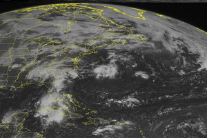
This NOAA satellite image taken Sunday at 9:45 a.m. Eastern time shows a slow moving cold front moving into the the Ohio River Valley and extending southward through the southern Mississippi Valley. This front will soon become a stationary front and be the focus for some showers and thunderstorms. High pressure building in behind this front will bring pleasant weather to the Midwest. The remnants of Tropical Storm Erika continue to move off to the northwest and will bring some much needed rain to southern Florida. A trough of low pressure over the Southeast will bring heavy rain to the area. High pressure will stay in control over the Northeast and bring another fantastic summer day to the area.
Weather Underground/AP
Commuters in South Florida can expect a muggy Monday morning as former tropical storm Erika makes its final push in the region.
The storm – which soaked Puerto Rico and the US Virgin Islands Thursday and killed at least 20 people in the Caribbean island of Dominica Saturday – drenched a large swath of South Florida with intermittent squally rain and wind through Sunday and could continue to pound the area through Monday morning, the Miami Herald reports.
Erika also brought heavy rains to Haiti, killing at least one person in what may have been a landslide and possibly leading to an accident that killed four more.
Despite its toll, however, the storm also served as a test for how much Florida – and the rest of the United States – has improved in terms of predicting and preparing for hurricanes, just as the Gulf Coast commemorates 10 years since hurricane Katrina devastated the region.
“This was definitely a good drill in determining our level of preparedness,” Miami Fire Rescue Capt. Ignatius Carroll told the Herald.
In the decade since Katrina, scientists and researchers have developed a range of new technologies, from satellites and supercomputers to unmanned drones, that promise more-accurate forecasts to increase public officials' confidence in weather experts' advice, leading to a more urgent response that could save lives.
Had authorities been quicker to heed warnings about the calamitous potential of Katrina before it made landfall first in Florida on Aug. 25, 2005 and then in Louisiana on Aug. 29, some of the nearly 1,800 people killed may have been saved, forecasters speculate. Indeed, officials in New Orleans – which suffered the most from Katrina – did not issue mandatory evacuation orders until a day and a half after experts first warned the city could take a direct hit.
"It's really important to get the forecast right, but it's also really important to communicate the certainty of the forecast so there aren't those 36-hour lags," Peter Neilley, head of global forecasting services of The Weather Channel told Reuters.
The National Oceanic and Atmospheric Administration has since launched an initiative to improve hurricane forecasts by 50 percent by 2019.
Among the projects centered on improving predictions is the Cyclone Global Navigation Satellite System (CYGNSS), whose team includes researchers from NASA, NOAA, five universities, and the Southwest Research Institute, based in San Antonio, The Christian Science Monitor’s Pete Spotts reports.
The initiative involves eight suitcase-sized microsatellites “designed to provide more-accurate estimates of the strength of surface winds in a tropical cyclone's core, the central region just outside the storm's eye,” Mr. Spotts wrote. “These are the regions with the heaviest rainfall, impenetrable to existing satellites.”
Researchers associated with the mission also hope to see improvements in forecasts of changes in storm intensity, he added.
Of course, "The atmosphere is fundamentally chaotic and unpredictable," Jeff Masters, a private forecaster with The Weather Co's Weather Underground division told Reuters. "There's a limit to how much certainty we can have in the modeling."
This week, government forecasters struggled to predict Erika’s strength as the storm swept through the Caribbean toward Florida because mountainous islands and hostile winds interfered with the weather system.
Still, city officials said the situation could have been worse. Thanks to additional storm pumps installed last week, standing water was not a problem in flood-prone areas like Miami Beach and Hollywood, Miami Beach spokeswoman Nanette Rodriguez told the Miami Herald. At the same time, as the storm struck the Caribbean, Florida residents rushed to activate hurricane plans and make emergency trips to the grocery store.
“Thank goodness everything is looking good so far,” Ms. Rodriguez said.
This report includes material from Reuters.

