Irene challenges forecasters on storm intensity
Tropical storm Irene illustrates improvements that forecasters have made in forecasting a hurricane's track. But it also highlights needed improvements in forecasting storm intensity.

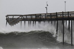
Waves break along the pier damaged during tropical storm Irene, in Ocean City, Maryland, Sunday. Irene lashed New York with heavy winds and driving rain, flooding some of Lower Manhattan's deserted streets and large parts of the northeast. But the feared major devastation was avoided as the storm lost some of its punch.
Molly Riley/Reuters
As tropical storm Irene spends what's left of its wind and rain over the Northeastern US, the rise and fall of the Atlantic season's first hurricane highlights improvements that forecasters have made over the past several decades in forecasting a storm's track.
But it also highlights the challenges that remain as researchers try to bring the same level of improvement to storm-intensity forecasts.
Within the next 10 years, research efforts sponsored by the National Oceanic and Atmospheric Administration aim to cut average track and intensity errors to 50 percent of what they were in 2008, according to Frank Marks Jr., director of the Hurricane Research Division at the Atlantic Meteorological and Oceanographic Laboratory in Miami.
At the same time, researchers are aiming to provide forecasters at the National Hurricane Center in Miami with the tools to extend their forecasts out to seven days from five days out today.
The efforts come against the backdrop of continued population growth along the coasts, as well as a warming climate.
Early last year, a team of tropical-climate specialists from the US, Australia, China, Japan, and India summarized the state of research into the tropical-cyclone connection to global warming.
[ Video is no longer available. ]
Writing in the journal Nature Geoscience, they noted it's unclear if global warming has had an effect on past hurricane trends. A bit like a radio signal buried in static, any global warming signal has been swamped by natural variations in hurricane frequency and intensity and by inconsistent quality and coverage of tropical-cyclone records worldwide.
Still, based on today's understanding of how these storms work and climate simulations built on that knowledge, "future projections consistently indicate that greenhouse gas warming" will boost the average intensity of tropical cyclones around the world by 2 percent to 11 percent by 2100.
And while the overall number of storms in a given season is expected to drop by 6 percent to 34 percent by century's end, a higher proportion of the storms that do form are expected to muscle their way into the top intensity rankings.
In Irene's case, forecasters at the National Hurricane Center in Miami had a bead on the storm's path up the US East Coast by early evening last Tuesday.
As Irene began its encounter with the southern Bahamas, forecasters had the track moving across the eastern tip of North Carolina and up the eastern seaboard. Forecasts of the storm's post-Carolina track wobbled back and forth slightly as NOAA and US Air Force Reserve hurricane hunters took the storm's measure as often as once every three hours.
But the shifts were relatively small. And the storm was large – hurricane winds as far as 90 miles from the center and tropical-storm winds out to 250 miles at the storm's peak.
Where track forecasts can by off by as much as 250 miles at the fifth day out, this time Irene took no significant deviation from the path along the mid-Atlantic and Northeast coasts forecasters had indicated early in the week.
Last Tuesday's forecasts expected Irene would strike North Carolina as a major hurricane, with maximum sustained winds of at least 110 miles an hour. When the storm made landfall near Cape Lookout at 11:30 a.m. Saturday morning, however, maximum sustained winds had dropped to 85 miles an hour.
Friday morning, forecasters noticed that dry air – anathema to tropical cyclones – was moving in from the west. And the storm was encountering increasing shear – rapid changes in wind speed and direction with height. Indeed, later in the day, forecasters noted that by the time Irene reached southern New England, the storm could become a high-end tropical storm, rather than a low-end hurricane.
But the tiny differences in effect between the two, especially along exposed coastlines, prompted forecasters to stick with Irene as a weak hurricane into New England a bit longer.
As Irene's center cleared North Carolina, it moved into an increasingly hostile atmospheric environment, as well as over cooler ocean waters.
In the end, Irene passed over a flooded New York City as a tropical storm around 9 a.m Sunday morning and has continued its arc inland through western Connecticut and Massachusetts.
