Where's the white stuff? Why northern tier of US is mostly snowless.
Initial forecasts called for a doozy of a winter, with lots of snow. But that has not materialized up north. If New York City doesn't see snow by Saturday, it will have only its third snowless December in 140 years.

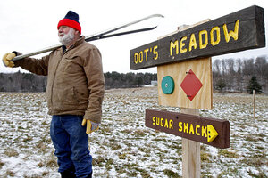
Burr Morse stands at a trail marker on his snowless cross-country ski trail Monday, Dec. 19, in East Montpelier, Vt. From New England to the Dakotas and even parts of the Northern Rockies and Pacific Northwest, snowfall has been well below normal through the fall and early winter with cold air bottled up over Canada. Many downhill ski resorts are making snow to compensate for nature's stinginess.
Toby Talbot/AP
Chicago
If your Christmas had everything – holiday lights, a visit from Santa, a family meal – what likely went missing was snow.
So far this winter, the northern US – from New England to the Dakotas – has most eluded snow and sub-freezing temperatures. In cities that were digging out of storms at this time last year, temperatures have been almost double the average.
Examples on Monday: It was 52 degrees F. in Minnesota's Twin Cities, 27 degrees above average. In Chicago, temperatures reached 45 degrees, making it the 16th day this month that temperatures exceeded 40 degrees. Fewer than 2 inches of snow have fallen in Chicago so far this season, according to the WGN Weather Center here.
The story is the same in the east. Slammed with a blizzard, New York City was grapping with more than 20 inches of snow by this time last year. No flakes have fallen this season to date. If none is recorded in Central Park by New Year’s Eve, it will be only the third year in 140 years of recorded weather history that the city hasn’t seen snow in December.
Although the National Climatic Data Center does not yet have total results for December, it reports that 13 states in the Northeast and the upper Midwest recorded a top-10 warmest November and none had a top-10 coldest November. The month was the 25th warmest in the center's 117 years of recordkeeping.
However, snowbirds who now see no reason to fly needn’t give up their plane tickets to Florida yet, says Alan Reppert, a senior meteorologist with AccuWeather in State College, Pa.
“It still is early in the winter season. We still have several months to get snowfall,” Mr. Reppert says.
AccuWeather meteorologist Josh Nagelberg, a colleague of Reppert, had predicted back in October that the Midwest and Great Lakes region would be, starting in December, experiencing the harshest winter in recent memory, due to record-breaking snowfall averages and blasts of Arctic air. Mr. Nagelberg emphasized his forecast with a doomsday quote that went viral for days: “People in Chicago are going to want to move after this winter.”
Accuweather’s Reppert could not explain why the prediction has so missed the mark, at least so far. For the year overall, warmer temperatures resulted in heavier rainfall – 2011 is expected to be the wettest on record in Chicago, for example, he says. “If any of those storms fell as snow, it would have been pretty well close to a normal December in those areas,” he says.
One reason for the unpredictability in gauging winter weather is the Arctic Oscillation, an atmospheric pattern of the northern latitudes that is difficult to predict more than two weeks in advance, says Angela Fritz, an atmospheric scientist with the Weather Underground, a media outlet located in San Francisco that specializes in long-range forecasting.
Winter conditions in the upper tier of US states are often determined by the strengthening of pressure systems around the Arctic. When pressure systems are weak, cold air that is normally trapped flows southward, resulting in extreme winter conditions for the US and Western Europe, says Ms. Fritz.
While that was the case for the past two winters, Arctic high-pressure systems this year are “allowing the cold air to get trapped up north,” says Fritz. “Last year, the refrigerator door was left open. This year, the refrigerator door was left closed.”
Due to the unpredictability of the system, meteorologists know only that the milder temperatures will continue through mid-January. But even without the colder air, snowflakes are possible.
“The Arctic Oscillation doesn’t mean we won’t get snow. It means, in the grand scheme of things, we won’t get an extreme winter like we did in 2010 and 2011,” Fritz says.
