Why tropical storm Debby is such a wet, sloppy slow poke
Like the guest who overstays her welcome, tropical storm Debby is inclined to just sit over the Florida panhandle – and dump more rain than any host could possibly absorb. How much longer will it stay?

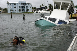
Diver Calvin Longstaff briefly swims away from a sunken boat at Pass-a-Grille, Fla. Marina on Monday, June 25. High winds and heavy rains spawned by the approaching Tropical Storm Debby caused the damage.
Dirk Shadd/The Tampa Bay Times/AP
For residents of Florida's panhandle and into southeastern Georgia, tropical storm Debby might as well be renamed Debby the Drencher.
Fed by warm Gulf waters, the slow-moving tropical cyclone dumped upwards of 20 inches of rain on the panhandle on Monday. Forecasters in Tallahassee anticipate another three to six inches of rain Tuesday as the storm's center, currently about 107 miles northwest of Clearwater, Fla., moves toward the northern Florida coast.
As of 11 a.m. Tuesday, forecasters at the National Hurricane Center in Miami put the storm's probable landfall at Waccasassa Bay, about 75 miles north of Clearwater, about 8 a.m. Wednesday.
Over land, Debby is expected to weaken to a tropical depression. But by 8 a.m. on Friday, the storm will have moved over the Atlantic and regained tropical-storm status as it veers to the northeast.
The storm is packing maximum sustained winds of 40 miles an hour, and is moving east at a leisurely 3 miles an hour.
For residents of the northeast Gulf, Debby's departure, when it comes, will be none too soon.
Earlier Tuesday, Florida state troopers reportedly shut down a 50-mile section if Interstate 10, just east of its intersection with I-75 near Lake City, Fla., because of flooding. High winds and flooding also prompted authorities to close two major arteries over Tampa Bay that connect Tampa to St. Petersburg.
Widespread flooding remains the biggest concern for state emergency managers, Florida Emergency Operations Center spokeswoman Julie Roberts told USA Today, noting that "Debbie is going to be around for the next couple of days, and while it sits there, it's going to continue to drop rain."
Storm surge is another looming issue, adds Dennis Feltgren, spokesman for the National Hurricane Center (NHC) in Miami. "Some of the worst storm surge probably is going to be occurring today in the big-bend area [where the panhandle merges with the Florida peninsula] because the wind is now going to be onshore instead of offshore."
Debby's crawl across the northeastern Gulf can be traced to the storm moving through a kind of doldrums in winds at the altitudes that tend to steer tropical cyclones.
Debby found itself between two branches of the jet stream – the polar jet to the north and the subtropical jet to the south, explains Jeff Masters, director of meteorology with the online service Weatherunderground.com. At the same time, Debby has been caught between two broad regions of high atmospheric pressure – one over the west-central US and the other over Puerto Rico and the island of Hispanola.
The relative positions of these key players – including Debby – left winds that otherwise might have moved the storm along in a very weak state. That left Debby to drift along the northern Gulf in slow motion.
Debby's position in the Gulf "brought up incredible amounts of tropical moisture," the NHC's Mr. Feltgen adds. Powerful updrafts hoisted that moist air into the storm to feed it. That led to the formation "of bands of just horrific rainfall," he says.
Such bands formed Monday afternoon, well ahead of the storm's center, "and that turned out to be a 20-inch dumper" on the panhandle, he says. "That's very typical of these slow-moving tropical storms."
In addition, on Sunday the storm spawed 20 tornadoes.

