Oklahoma tornado: How accurate were predictions?
The devastation that the tornado wreaked on Moore, Okla., highlights both the progress forecasters have made and the remaining challenges they face in predicting such events.

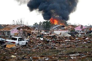
A fire burns in the Tower Plaza Addition in Moore, Okla., following Monday afternoon's powerful twister.
Sue Ogrocki/AP
A 2013 tornado season that began with a whimper has suddenly ramped up with all the explosiveness of the powerful tornado-generating thunderstorms that have erupted in the past few days – with Moore, Okla., taking the brunt.
The death toll from Monday afternoon's powerful twister stands at 24, a number that public-safety officials have said is likely to rise as search-and-rescue teams carefully pick through rubble in the hunt for survivors.
Forecasters at the National Weather Service (NWS) forecast office in Norman, Okla., have given the twister a preliminary rating of EF-4, the second-highest rating on the tornado-severity scale, with winds ranging from 166 to 200 miles an hour. It could well be increased to an EF-5, with winds exceeding 200 miles an hour, after forecasters complete post-storm damage surveys.
Indeed, the storm was powerful enough to lift some of the lighter debris it generated and deposit it around Tulsa, Okla., some 100 miles away.
Moore is no stranger to EF-5 twisters. In 1999, such a tornado spun its way through the city, following much the same path as Monday's twister. That event killed 36 people, destroyed 1,800 homes, and damaged another 2,500. After adjusting for inflation, the tornado inflicted $1.4 billion in damage – the fourth most costly tornado on record in the United States. Some specialists say they expect the damage from Monday's tornado to overtake the current recordholder of $2.8 billion – the tornado that hit Joplin, Mo., in May 2011.
The devastation wreaked on Moore highlights both the progress forecasters have made and the remaining challenges they face in predicting such events.
Based on a large-scale weather pattern favoring severe thunderstorms that persisted through the weekend, forecasters had a good bead on where and when the highest risk for large, damaging hail and tornadoes would present itself.
On Sunday, tornadoes erupted in the region, including an EF-4 that hit Shawnee, Okla., Sunday – an event that killed two people but inflicted relatively little structural damage because the track went over mostly rural areas.
By 11:30 Monday morning, forecasters in Norman released information that indicated Monday's atmospheric conditions could make for a day as bad or worse. On Sunday, enormous "supercell" thunderstorms had cropped up from a cloudless sky, in less than an hour becoming towering anvils that dropped baseball-sized hail and tornadoes, according to Rick Smith, the warning coordination meteorologist at the NWS forecast office in Norman.
In a video posted to YouTube as part of the office's get-out-the-word effort, Mr. Smith noted that as with Sunday's storms, forecasters expected explosive development on Monday, with storms popping up as early as noon in some areas. For the area that included Moore, the period for peak activity would occur between 3 and 6 p.m., Smith said.
"I would not be at all surprised to see similar tornadoes occurring today" in the area that included Moore, he said, referring to the previous day's EF-4 tornado.
Of special concern, he added: Unlike Sunday, schools were in session, and the window of highest risk that forecasters identified included the rush hour.
Based on conditions, a tornado watch was posted for Monday. The storm generating the tornado that hit Moore triggered a tornado warning 16 minutes before the twister touched down at about 2:56 Monday afternoon. Over the next 40 minutes, it would cover 20 miles on a path that took it through the heart of Moore.
Yet for all that apparent prescience, forecasters still have a hard time estimating in advance where any single supercell might appear. And even if they could do that, researchers have long pointed out that relatively few supercells actually spawn tornadoes. So figuring out which could become tornadic also presents a challenge.
Researchers currently are engaged in a month-long project in the Plains to gather more-detailed information on supercell storms in hopes of increasing the lead time in predicting their appearance, as well as better pinpointing where they will pop up.
Josh Wurman, a researcher working with mobile weather radar designed to tease out details within a storm, acknowledges the problem.
"I was in southern Oklahoma yesterday afternoon," he told NPR's "Morning Edition." "I had just driven through Moore and was in what I and most others who were pursuing storms thought would be the risky area for storms."
He ended up "a few dozen miles" south of the tornado's starting point.
"That points out the real limitation of our skill in being able to forecast tornadoes," he said. "We don't really know exactly where they're going to occur."

