Tropical storm Karen prompts hurricane watch from Louisiana to Florida
Landfall for tropical storm Karen is projected for early Sunday morning just east of Mobile, Ala. But forecast uncertainties mean it could come ashore anywhere from the New Orleans area to Indian Pass, Fla.

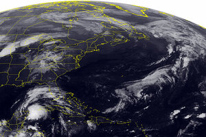
This NOAA satellite image taken Thursday, Oct. 3, 2013 at 1:45 a.m. EDT shows a low pressure system tracking across the Northern Plains with showers and thunderstorms. Areas of scattered showers are seen over the Ohio Valley and Tennessee Valley. Farther south a tropical disturbance is seen moving into the eastern Gulf of Mexico. Fair weather is seen over the Northeast.
Weather Underground/AP
A hurricane watch has been posted for a swath of the US Gulf Coast stretching from Grand Isle, La., to Indian Pass, Fla., following the emergence of tropical storm Karen from an intense storm system just off the tip of the Yucatán Peninsula. [Editor's note: The original version of this paragraph contained a reference to tropical depression that was not entirely correct.]
In addition to the hurricane watch, which means tropical-storm-force winds are expected within 48 hours, a tropical-storm watch has been issued for a stretch of the Gulf Coast that reaches west from Grand Isle to Morgan City, La. The tropical-storm watch covers the New Orleans metro area, as well as Lake Pontchartrain and Lake Maurepas.
At 11 a.m., Eastern time, the storm was centered about 360 miles east southeast of Havana and was traveling into the northern Gulf of Mexico at about 12 miles an hour. Karen is packing maximum sustained winds of 65 miles an hour with gusts up to 75 miles an hour – hurricane-force gusts. Tropical-storm-force winds extend up to 105 miles from Karen's center.
Forecasters anticipate the storm will intensify into a hurricane Friday afternoon before weakening to a tropical storm by Saturday afternoon. Landfall is projected for early Sunday morning just east of Mobile, Ala.
Uncertainties in track forecasts this far in advance of landfall, however, point to the possibility of the storm coming ashore anywhere from the New Orleans area to Indian Pass. The actual track could affect the storm strength at landfall: A shift to the west of the currently projected path would yield a weaker storm, while a shift to the east would strengthen it, forecasters say.
Despite the storm's expected weakening prior to landfall, it could still be near hurricane strength when it crosses the coast, forecasters at the National Hurricane Center in Miami say.
Once the storm comes ashore, it is expected to head northeast, cutting across the southeast corner of Alabama, then across Georgia, and into eastern South Carolina as a tropical depression. By Tuesday, forecasters say they expect Karen's remnants to merge with a weather front along the Eastern Seaboard.

