Texas floods: Does urban sprawl put more homes in path of flooding?
The question of where and how to build is one that is only going to become more pertinent to urban planners, experts say.

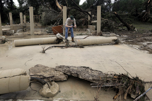
Joel Venable examines the remains of a friend's vacation home that was swept down the swollen Blanco River, Tuesday, in Wimberley, Texas.
Eric Gay/AP
Dallas
The booming economy of Central Texas and the rampant development that comes with it may have played a role in exposing area communities to increased flood risk.
The region was one of the worst-hit by Memorial weekend flash flooding, leading to at least 19 deaths and numerous missing after torrential downpours in Texas and Oklahoma.
While not every flood expert sees a cause and effect relationship – and efforts right now are focused on helping those who have lost their loved ones and their homes – the question of where and how to build is one that is only going to become more pertinent to urban planners, experts say. That’s true for both flood plains and areas prone to wildfire, where causes ranging from population growth to the beauty of the surroundings have inspired people to build homes in areas that might not historically be suited to them.
Over the weekend, the Austin area, one of the fastest growing in the country, saw some of the most severe rainfall and flood damage. Hays County, to the city's southwest and considered at the heart of what has become known as Flash Flood Alley, was the fastest-growing county in Texas last year and fifth-fastest in the US, according to US Census Bureau data.
The pressures of a skyrocketing Texas economy has led to a building boom, experts say, and there are questions about whether flood risk played second fiddle. The speed of new construction is an additional complication, since homes are going up faster than rivers and creeks can be mapped.
Local flooding expert Steve Graham says that when it comes to whether urban sprawl played a role in the numbers of homes lost in this week's flooding, the answer is a more nuanced, "maybe, maybe not." He noted that in a primarily rural place such as Wimberley, which also was hard hit by the flooding, climate, topography, and randomness also played a significant role in flooding.
But in general, he explains, “urban development not done properly can increase the risk of flooding at the development and downstream of the development.”
Multiply those types of developments by 10,000, and the negative effects are compounded, adds Mr. Graham, the assistant general manager of the San Antonio River Authority and co-chair of the National Association of Flood and Stormwater Management Agencies' flood management committee.
Statistics suggest the building boom may, in some cases, exacerbate destruction caused by floods.
Nicholas Pinter, a floodplains expert in the department of geology at Southern Illinois University, points to a 2006 Federal Emergency Management Agency-funded study that suggested ongoing development in Harris County, in which Houston is located, would increase flood losses to existing infrastructure by some 1,200 percent.
"That's the increase to existing structures," he says, "then add the new exposure from all that new floodplain infrastructure."
An added complication in Texas is the speed with which some cities are growing.
San Marcos, for example, “is the fastest growing mid-sized city over 50,000 in America according to the latest census data," J. Wylie Donald, a Washington, D.C.-based lawyer, wrote in Lexology. "Literally hundreds of new homes are rising every year.”
Mr. Donald and Graham both point to a dire need for better mapping of creeks and rivers to identify potential floodland before it’s converted from pasture or farmland to a subdivision.
"We never get ahead of development from a risk identification or mapping perspective," says Chad Berginnis, executive director of the Association of State Floodplain Managers, who says mapping is a national problem. "In the meantime, new development encroaches on watercourses that have never been studied and with few exceptions, community subdivision standards do not require mapping of those small creeks and watercourses that will be tomorrow’s floodplains."
Of the more than 3.5 million miles of streams and coastlines in the US, the FEMA flood maps only identify floodplains on 1.2 million miles of them, Mr. Berginnis says.
"So while FEMA flood maps are a good starting point to identify flood risk, they are rarely adequate to fully identify flood risk in rapidly growing areas of communities where land is being converted from pastures or farmland to residential and commercial development," he says.

