
Wisconsin slammed by storms, possible tornado
Wisconsin was battered by heavy winds and rain Monday, as a front moved through the area. Almost 50 million Americans from Wisconsin to Ohio and Kentucky were facing the threat of severe thunderstorms.
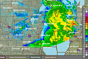
National Weather Service radar image from 7:03 a.m. CDT Monday.
National Weather Service
Milwaukee
Severe thunderstorms have caused wind damage around Wisconsin — especially in Dodge County where a tornado warning was issued.
There were no reports of any touchdowns early Monday, but the area received 4 to 5 inches of rain with winds over 60 mph.
We Energies reports more than 30,000 customers are without power because of the storms. There are reports of heavy flooding in Sheboygan County as the storms push out over Lake Michigan.

Almost 50 million Americans from Wisconsin to Ohio and Kentucky were facing the threat of severe thunderstorms and possible tornadoes Monday, forecasters said.
Damaging winds, heavy rain and lightning were likely for many parts of the Midwest, according to the Weather Channel.
Tornado sirens sounded in several counties in Wisconsin, while central Illinois was a greatest risk of twisters. However, the larger threat was from thunderstorms and localized flooding in areas that have already seen heavy rainfall.
Weather Underground forecasts that a stationary front will stretch across the Midwest on Monday, extending from across the upper Mississippi Valley and the Ohio Valley.
This frontal boundary will be the focal point for strong to severe thunderstorms on Monday. Severe thunderstorms will be possible across a handful of states, including eastern Iowa, southern Wisconsin, eastern Missouri, Illinois, southwest Michigan, Indiana, Ohio, western West Virginia, western Virginia, Kentucky, Tennessee, northern Georgia and northern Alabama. These thunderstorms will be capable of producing large hail, dangerous straight line winds and isolated tornadoes. In addition, heavy rain will bring threats of flash flooding to West Virginia, eastern Kentucky, southern Ohio and central Indiana.
Meanwhile, an onshore flow from the Gulf of Mexico will continue to usher warm air across the Plains. Temperatures are forecast to range between the 90s and 100s over the southern and central Plains. Just to the west, monsoonal moisture will aid in the development of showers and isolated thunderstorms over the Four Corners.
Additionally, an area of low pressure will slide eastward over the Northwest. This system will generate showers and thunderstorms over the Pacific Northwest, the northern Great Basin and the upper Intermountain West. High pressure will keep conditions quiet over California. Temperatures will jump into the triple digits over the Desert Southwest on Monday.
Temperatures in the Lower 48 states Sunday have ranged from a morning low of 35 degrees at Truckee-Tahoe, Calif. to a high of 102 degrees at Goodyear, Ariz.