Flooding, tornado hit San Antonio and other parts of Texas
A tornado touched down southwest of San Antonio Monday night damaging half a dozen homes. Severe flooding is forecast from Texas to Missouri over the next several days.

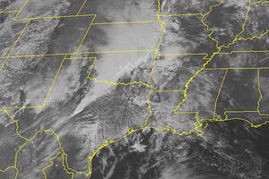
This NOAA satellite image taken Monday morning shows dense cloud cove as a cold front extending through the Plains meets with ample moisture spreading across the region from the Gulf of Mexico to produce significant rain and thunderstorms from northern Texas through eastern South Dakota.
(AP PHOTO/WEATHER UNDERGROUND)
Oklahoma City
Residents and businesses from southeast Texas north through western Missouri braced for flooding Tuesday after a violent band of storms brought heavy rain, hail and at least one tornado, with more of the same forecast for the next several days.
The National Weather Service said a tornado touched down Monday evening about 25 miles southwest of San Antonio. The twister damaged at least six homes, trapping some people inside their mobile homes, but no fatalities were reported, according to The San Antonio Express-News.
The fresh crop of storms comes after two tornadoes damaged homes and railcars in North Platte, Neb., on Sunday. The EF3 twister with winds up to 165 mph injured four people.
Flooding remains a serious concern across the affected areas. Love Field in Dallas got more than four inches of rain overnight.
IN PICTURES: Extreme Weather 2012
"The areawide deluge that blew in Monday afternoon may not let up until late this morning, triggering flooding across North Texas and making the early commute a nightmare. Flood warnings are in effect throughout North Texas on this first day of spring, and forecasters have extended the alerts for Dallas and Ellis counties until 10:45 a.m." reported The Dallas Morning News.
Eight inches of rain was expected in southeastern Kansas, which has been unusually dry for nearly a year. The area has had less than three-fourths of the precipitation it typically gets since last April, state climatologist Mary Knapp said.
The weather service said some low-lying areas experienced flash floods, including along the Marmaton River at Fort Scott, Kan. Forecasters said the river would likely exceed flood stage later Tuesday, but drop again Thursday when the rain subsides.
Emergency management officials said they're keeping an eye on the clouds but feel that southeast Kansas can handle several days of rain.
In Arkansas, however, emergency management officials readied teams to respond to flash floods, especially in the western part of the state where the heaviest downpour was expected. The U.S. Forest Service closed campsites preemptively Monday, exercising caution after 20 people died in a flash flood at a remote campground in 2010.
Forecasters in Tulsa, Okla., said the slow-moving storm was expected to stall over the area, dumping up to 12 inches of rain in isolated areas.
"When rain falls in those terrain areas" — especially the hills and valleys — "it's quickly funneled into small rivers and streams," said B.J. Simpson, a National Weather Service meteorologist. "Those are the most dangerous areas."
Still, even flatlands could see the potential for runoff and flash floods if the rain comes too fast for the ground to absorb it.
"There's really no amount of dry ground that can take up to 10 inches of rain in a couple day timeframe," Simpson said.
Thousands of customers lost power in San Antonio and Dallas-Fort Worth, where strong winds and rain pelted the area, and power outages were reported in Oklahoma City and Tulsa County. Flights were stopped temporarily Monday night at Love Field airport and some 35 flights were canceled Tuesday at Dallas-Fort Worth International Airport.
___
Associated Press writers Bill Draper in Kansas City, Mo., Rochelle Hines in Oklahoma City, Nomaan Merchant in Dallas and Jeannie Nuss in Little Rock, Ark., contributed to this report.

