Hurricane Simon now at Cat. 3, but where is it headed?
Hurricane Simon sustained winds strengthened Saturday to 115 m.p.h. Forecasters expect the hurricane to begin weakening Sunday, but Simon's track is still uncertain.

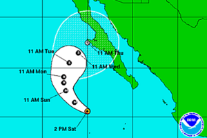
Coastal Watches/Warnings and 5-Day Forecast Cone as of 5 pm Eastern time Saturday.
National Hurricane Center
Miami
Simon has strengthened into a Category 3 hurricane in the Pacific, but probably poses no direct threat to land.
The U.S. National Hurricane Center in Miami says Simon's maximum sustained winds increased to near 120 mph (185 kph) on Saturday. Forecasters say Simon is expected to begin weakening Sunday.
The center says the hurricane is centered about 350 miles (565 kilometers) southwest of the southern tip of the Baja peninsula and is moving west-northwest at 13 mph (20 kph). There are currently no coastal watches or warnings in effect.
But the National Hurricane Center computer models disagree as to which way Simon is headed, how much stronger it will get, and whether it will hit Baja California.
Simon is expected to move west-northwest to northwestward for the next 36 hours or so as is approaches a weakness in the subtropical ridge to its north. After that, the system is expected to turn northward and northeastward, although there remains significant spread in the track guidance on when and how fast this will occur.
The GFS, GFS ensemble mean, NAVGEM, and the GFDL show Simon moving quickly to the northeast, eventually making landfall on the Baja California peninsula and in northwestern Mexico.
The ECMWF, UKMET, and CMC models show the turn occurring later and farther west, and these models forecast the cyclone to dissipate over water west of the Baja California peninsula. The forecast track continues to compromise between these two extremes in showing a slow northeastward motion after recurvature. The new forecast track is similar to the previous track and is slower than the model consensus.
How long the current rapid intensification will continue is uncertain, as Simon is now moving over decreasing sea surfacetemperatures. The new intensity forecast follows the guidance trend of showing 12 hours more strengthening. Simon is now forecast tobecome a major hurricane, and it would not be a surprise if it reached a higher peak intensity than currently forecast.
Simon is expected to produce 2 to 4 inches or more of rainfall in southwestern Mexico and swells generated by the hurricane could cause life-threatening surf and rip current conditions.

