Five killed in east Texas flooding Saturday
A woman and four children were killed early Saturday after a creek overflowed its banks, flooding an East Texas neighborhood as many residents slept.

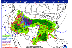
National Weather Service forecast issued early Saturday morning for the weekend shows heavy rain in dark green across swaths of the US.
National Weather Service
Palestine, Texas
A 64-year-old woman and four grandchildren were killed early Saturday after a creek overflowed its banks, flooding an East Texas neighborhood as many residents slept.
Capt. James Muniz of the Palestine Police Department told The Associated Press that six to 10 homes in a Palestine cul-de-sac were severely damaged following heavy rainfall over the course of just a few minutes after midnight. All other residents of the cul-de-sac were accounted for, he said.
City crews found the five bodies — including the four children, all younger than 9 — near one of the homes before dawn after the floodwaters had receded.
"The water came down the hill," Muniz said. "The street was full of mud, so the water just came up. With the enormous amount of rain we had, we had people tell us that within minutes, the water was waist deep."
City officials used a dump truck to rescue one man from the roof of a home, Muniz said.
One neighbor told authorities that he saw the family but lost sight of them as he waded through waist-deep water.
In Houston, Click2Houston warns of more rain and flooding Saturday morning.
Two distinct areas of rain are still a concern for Houston. One cluster of slow-moving storms will drift through Houston from the north, while another line of thunderstorms will converge on Houston from the west.
The biggest threat from these storms will continue to be flooding. While we do not anticipate widespread severe flooding, local heavy downpours will cause minor flooding on roads and swollen bayous and creeks. Gusty wind, small hail and isolated weak tornadoes are less likely, but still possible, as the storms pass.
The thunderstorms should exit Metropolitan Houston by 10 o'clock Saturday morning. After that, much quieter conditions will persist for the remainder of the day and the flooding threat decreases significantly. At best, isolated showers could develop later Saturday afternoon as a result of daytime heating.
The National Weather Service forecast issued Saturday morning for the weekend says:
A strong storm over the Central Plains/Middle Mississippi Valley will slowly move eastward to the Ohio Valley by Sunday evening.
Showers and thunderstorms will develop along and ahead of the associated front from parts of the Lower/Middle Mississippi Valley and the Western Gulf Coast that will move to the Great Lakes/Ohio Valley and Central/Southern Appalachians, while extending southwestward to the Lower Mississippi Valley by Sunday morning.
The showers and thunderstorms will expand into parts of the Southern Mid-Atlantic/Southeast by Sunday evening.
Rain and higher elevation snow will develop over parts of the Central Rockies and Central High Plains through Sunday morning.
In addition, rain will develop over parts of the Central High Plains eastward to parts of the Western Ohio Valley on Saturday morning that will expand into parts of the Upper Great Lakes and parts of the Northeast/Northern Mid-Atlantic by Sunday morning.
Rain will continue over parts of the Central High Plains/Central Plains through Sunday afternoon. Similarly, rain will continue over parts of the Middle Mississippi Valley/Western Ohio Valley through Sunday evening.
Meanwhile, upper-level energy will settle into parts of the Great Basin/Southwest and expand eastward to parts of the Southern High Plains by Sunday evening. The system will produce rain over parts of the Northern Intermountain Region southward to parts of Central/Southern California and the Southwest by Saturday morning.
Rain with embedded thunderstorms will develop over parts of the Northern Intermountain Region southward to parts of the Southwest and expand into parts of the Southern Rockies by Saturday evening. The rain and embedded thunderstorms will end over the Northern Intermountain Region/Great Basin by Sunday morning.
On Sunday morning rain will continue over parts of the Southwest/Southern Rockies. Rain and higher elevation snow will develop over parts of the Central Rockies/Central High Plains on Sunday morning into Sunday evening.
By Sunday evening, rain with embedded thunderstorms will develop over parts of Central/Southern California and extend eastward to parts of the Southern High Plains. Also on Sunday, moisture from the Gulf of Mexico will move westward over the Western Gulf Coast into parts of Western Texas producing showers and thunderstorms over the region.

