
Malaysia Airlines Flight MH370: Robot sub back at work after false start
The Bluefin-21 sub had to abort its first mission because it reached a patch of ocean exceeding its maximum depth capacity. But it's now resumed its search for Malaysia Airlines Flight MH370.
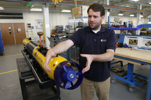
Will O'Halloran, director of marine operations at Bluefin Robotics, explains how this autonomous underwater vehicle steers, on March 28 in Quincy, Mass. The US Navy has provided one of Bluefin's AUVs to aid in the search for missing Malaysia Airlines Flight MH370.
Melanie Stetson Freeman/Staff
The US Navy underwater robot Bluefin-21 has returned to the depths of the Indian Ocean in search of missing Malaysian airliner MH370 after aborting its first scouting mission.
The multinational team of searchers launched the autonomous underwater vehicle Monday, nearly a week after pings believed to be transmitted by the missing jet’s black boxes went silent. But the sub aborted that mission after reaching a patch of ocean that exceeded its maximum depth capacity.
“That part of the area was deeper than we thought it would be,” Navy spokesman Chris Johnson says. “We’re not entirely clear what we are going to run into, though we are fairly confident we are searching in an area now that is within the depth parameters.”

The Bluefin-21, which is manufactured by Bluefin Robotics in Quincy, Mass., is capable of traveling up to 4,500 meters about 2.8 miles) below the ocean surface, Bluefin CEO David Kelly told the Monitor during an interview in late March.
That’s plenty deep for the majority of the Indian Ocean, which has an average depth of roughly 3,900 meters. However, portions of the search area known as the Zenith Plateau, which is about 1,000 miles northwest of Perth, Australia, reach nearly 5,000 meters deep.
When it comes to deepwater exploration, pressure is the limiting factor.
Mr. Kelly describes the pressure at 4,500 meters as “equivalent to a Cadillac Escalade balanced on your thumbnail.”
Oil-filled bladders protect the sub's internal communication system, data storage compartment, and surveillance technology from those pressures, but are not guaranteed to withstand additional force.
While the sub is capable of forming an image of what it “sees” by piecing together acoustic waves captured by sonar, it has to be about 50 meters above the seafloor to capture a reliable image, Bluefin's director of marine operations, Will O’Halloran, told the Monitor during a tour of Bluefin Robotics on March 28. To capture an optical image, it has to get even closer.
Although operators program search constraints for the sub, as an autonomous vehicle, it determines its own course, Mr. O’Halloran explained. In this case, operators aboard the Australian Royal Navy ship Ocean Shield preprogrammed a search area with the mission to “fly” 50 meters above the seafloor and obtain an image.
Because the Zenith Plateau is outside Australia’s economic zone, it has not been mapped extensively. It was not until the Bluefin-21 attempted to follow along the seafloor at the prescribed distance that the extent of the depths became clear. Rather than compromise the onboard equipment by exceeding the sub's maximum depth capacity, the vehicle aborted its mission and returned to the surface.
Authorities were already aware of the drone’s limitations but have not yet been able to obtain a vessel capable of searching deeper ocean.
“I would caution you against raising hopes that the deployment of the autonomous underwater vehicle will result in the detection of the aircraft wreckage. It may not,” search coordinator Angus Houston said at a news conference prior to the aborting of the first mission. “However, this is the best lead we have, and it must be pursued vigorously. Again, I emphasize that this will be a slow and painstaking process.”
It takes the Bluefin-21 an entire day to complete a single mission – two hours to reach the bottom, followed by 16 hours of searching and another two hours to return to the surface. If the sonar data reveal anything of interest, operators must initiate a second complete mission to obtain optical images. Authorities speculate that the search process could take another two months.
• Material from The Associated Press and Reuters was used in this report.