California fires: how drones can provide essential information
Firefighters have used information compiled with remote sensing technology to help contain several wildfires blazing through southern California this summer.

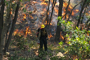
A Hotshots member from the US Forest Department sets a back fire while battling the the so-called "Sherpa Fire" in the hills near Goleta, Calif., on June 16. Firefighters have worked to contain several wildfires that have blazed through southern California this summer, using information compiled with remote sensing technology.
Mario Anzuoni/Reuters
The fire crews fighting the San Gabriel Complex fire near Los Angeles found a much-needed respite in Tuesday's weather.
It wasn't rain that helped them slow the 4,900-acre burn. Clear skies enabled them to use aerial mapping and shift the two-fire system into 10 percent containment, as the Associated Press reported.
The San Gabriel Complex fire is one of several southern California fires already burning hot and moving quickly in the early months of the West's fire season, but they are hardly exceptional. Recent years have seen an increase in the size and ferocity of Western wildfires that devastate landscapes, communities, and federal budgets every summer.
Wildfires are a natural – even essential – part of the West's myriad ecosystems, but managing their burgeoning intensity requires a better understanding of how and why they burn. Satellite and drone technology is an increasingly promising means of obtaining this information.
"Fire operations are heavily based on intelligence," says Robert Sohlberg, a principal faculty specialist at the University of Maryland and a lead investigator on the project to connect NASA's data with fire management. "They want to look at fire conditions and history ... it just gives them more information."
Information from satellites has been assisting fire officials more and more regularly since 2000, when scientists studying images from fires in Idaho and Montana realized that they could help firefighters plan operations more effectively, according to a report from NASA. NASA was already using satellites to collect heat-sensitive, infrared images around the globe, but to be useful, these images would need to reach forest management officials within 24 hours.
NASA's Rapid Response program emerged from a partnership between the space agency and the US Forest Service, helping scientists send images to the officials managing wildfires in real-time. This helps with wildfire detection and planning.
"It provides what we call a synoptic view, you can see the whole landscape at once several times a day," Mr. Sohlberg says. "Before the introduction of the satellite technology, there was no way to map the fires across Alaska, for example."
Mapping fires helps firefighters tailor their efforts to their volatile conditions. The Sherpa fire, for example, flared up on June 15 and grew rapidly by burning dry, shrubby chaparral, Sohlberg says. It moved so quickly it "created its own weather" through convection currents, challenging firefighters as it blew through canyons with high winds, but aerial technology allowed firefighters to track its movement and deploy airborne equipment over inaccessible areas.
With additional information, fire officials can better answer questions of tactics, Sohlberg says: "Where do we want to plan our firebreaks, where do we want our bulldozers, where do we want to put hand crews, where is it too dangerous to put hand crews?"
Heat-detection sensors attached to satellites, airplanes, and even drones have other tactical advantages. The infrared sensors can detect a campfire from thousands of feet up, for example. Whether they fly over an active fire or assist by locating flare-ups, they provide clues about to a fire's heat, speed, and intensity that help officials employ their limited equipment and manpower as efficiently – and safely – as possible.
Federal agencies that oversee firefighting are increasingly looking for ways to employ drones as well, because unmanned aircraft can descend toward flames to deploy fire retardant or gather data without endangering human life, as The Hill reported.

