How aerial mapping has helped contain San Gabriel Complex fire
Firefighters achieved 10 percent containment on Tuesday evening, the first sign of progress on the twin blazes of the Southwest's 'firenado.'

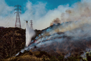
A fire helicopter makes a water drop on hotspots burning in Duarte, Calif., on Monday, June 20. Firefighters achieved 10 percent containment on Tuesday evening, the first sign of progress on the twin blaze of the San Gabriel Complex fire.
Watchara Phomicinda/San Gabriel Valley Tribune/AP
Reports called it "firenado" and a "heat wave blitzkrieg," but by Tuesday evening, firefighters had the information they needed to start containing the San Gabriel Complex Fire.
The weather helped, as firefighters took advantage of clear skies on Tuesday to employ aerial mapping and chart the fire's movement in real time, the Associated Press reported.
The Reservoir and Fish fires have been burning through the rugged foothills near Los Angeles since Monday, evolving quickly into a twin fire system that that firefighters are now combatting as a single, 4,900-acre wildfire as they work to keep the blaze away from people and property, the US Forest Service reported.
The wildfire shrank for the first time on Tuesday night, and firefighters ended the day with 10 percent containment on both fires.
Although private drones have been cited as a hazard to firefighting – California's legislature passed a bill punishing drone fliers who interfere with firefighting last year, although the governor vetoed the measure – aerial tools aid the efforts in significant ways. Jets and helicopters are flying hotshots into tough areas such as the California foothills while others pour gallons of red fire retardant on stubborn blazes.
Satellite and drone images are aiding firefighting strategy for the fires blazing throughout California, Arizona, New Mexico, and Utah, providing both information about the fire's current location and the geographical detail to estimate where it could go next.
To this end, NASA developed a Rapid Response system in 2001. The system provides a way to connect satellite images from its Moderate Resolution Imaging Spectroradiometer (MODIS) instrument on board the Terra research satellite with the firefighting work of the National Interagency Fire Center and the US Forest Service.
"By 2007, the Rapid Response System was producing data globally and had incorporated data and imagery from the MODIS instrument on the Aqua satellite," according to a NASA news release. "Users quickly realized that the imagery and data products produced by Rapid Response could be used for other tasks that required low latency products, including imagery for monitoring air quality, floods, dust storms, snow cover, agriculture, and for public education and outreach."
NASA has used MODIS to create satellite images of the San Gabriel Complex, which the forest and fire officials then use when deciding how to employ over 1,000 personnel currently working on the fire.
The aerial mapping strategy gives firefighters an extra edge toward containing the large fires, especially when they burn through steep or even inaccessible terrain.
"They are working so hard, it's excruciating with the heat, and up and down these hills, they're steep," Los Angeles County fire Capt. Mike McCormick told CBS News.
Despite the progress, evacuations will continue for at least one more night while firefighters work toward greater containment.
"We're looking at another night at least," US Forest Service spokesman Nathan Judy told CBS News. "We understand the stress it puts on families if you displace them from their homes, and we want to get them back as soon as we can."

