Another tough summer for Arctic sea ice
The annual melt-back of Arctic Ocean sea ice is deepening -- driven by the arrival of warmer weather and the thinness of the winter ice that rebuilt after last summer's melt.
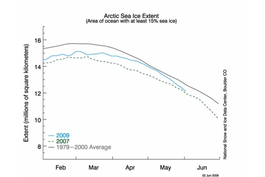
As of the latest readings posted at the National Snow and Ice Data Center on June 1, it looks for the moment like the melt-back's pace is flirting with the 2007 record.
How much farther the ice will retreat this year remains an open question. Scientists at the National Snow and Ice Data Center in Boulder, Colo., say much depends on seasonal weather patterns through summer's end.
May's decline was about average, the center notes. But given the thinness of the ice that emerged from winter and its growing predominance over hardier multi-year ice, NSIDC researchers say they expect 2009 to be another year when the amount of sea ice left at summer's end will fall short of the 1979-2000 average.
The decline of summer ice is driven by a mix of factors. Warmer waters move into the Arctic Ocean Basin from lower latitudes, for instance. And certain weather patterns, if they persist, can herd the broken ice out into the Atlantic like Rowdy Yates on the cattle trail.
But through it all, the underlying driver is widely seen as global warming, over whose long-term trend these other, more variable factors are superimposed.
So, if you're not into polar bears, who cares?
Well, a couple of recent studies suggest that a persistent deep decline in summer ice has a measurable effect on regional climate patterns at far lower latitudes the following fall and winter. In short, if you live in most of the continental US (including the already parched West), Alaska, and northern Europe, don't look for as much fall and winter rain and snow as you might otherwise get.
You can find a pdf copy of the formal research report, which has been published in Geophysical Research Letters, here. A modeling study by another group, and reaching somewhat similar conclusions, has been submitted for formal publication in the Journal of Climate.
These studies highlight a point that will crop up more frequently over the next few years: Like politics, in the end all climate is local. Global averages are useful benchmarks up to a point. But when it comes to global warming, the intensity of specific effects that people will have to cope with in specific locations will depend on a range of local and regional conditions -- from how close you live to the ocean or to major mountain ranges to the type of land-use practices people have evolved where you live.
We'll have more on this in future posts, but for now, let's stick with the potentially long reach of conditions in the Arctic.
Enter Jennifer Francis, a researcher at Rutger University's Institute of Marine and Coastal Sciences. She and four colleagues asked a simple question: If you look at real-world measurements, what sort of local and distant effects show up during years where summer sea ice scrapes bottom, figuratively speaking.
In a phone chat, she summarized what she and her team found.
During periods of larger than average summer sea-ice retreat, of course, more dark ocean is exposed to the sun. So the ocean absorbs heat, then releases it back into the atmosphere as fall sets in. This slows the pace at which the near-surface layer of air, the so-called boundary layer, cools.
In the Arctic, this layer typically tends to be very stable and very low to the ground compared with other parts of the globe. The extra warmth the oceans release, however, keeps this layer relatively warm. The warm air expands, increases the thickness of the boundary layer. This, in turn, enables it to hold more heat, Dr. Francis explains. This whole sequence slows the freezing process, retarding the return of winter ice.
This added warmth also allows the air to hold more moisture as seawater evaporates. Clouds increase. The clouds act as a blanket, trapping heat near the surface. And since the clouds appear in the fall, when the hours of daylight up there rapidly dwindle to zero, this heat-trapping effect offsets any cooling one might expect from cloud tops reflecting sunlight back into space.
So far, this is all local to the Arctic region.
But, Francis continues, her team also saw that the jet stream weakens during the fall and winter following a leaner than normal summer's worth of Arctic sea ice. The jet stream is a high-altitude, high-speed river of air that spins off eddies that become storm systems. It also steers the storms. Its strength is governed by the size of the temperature differences between the southern and northern portions of the hemisphere. And the net warming effect of low-sea-ice seasons reduces that north-south temperature difference.
The weakened jet stream and shifted storm tracks bring drier-than-normal conditions to much of North America, Alaska, and northern Europe. Conditions tend to be wetter than normal along eastern Greenland, through much of the western and central Mediterranean, Japan, and a patch of the Pacific Northwest.
These effects become most obvious when they aren't overwhelmed by big atmospheric features such as El Nino or La Nina.
"Some models do get some of this right," Francis says, pointing to yet-to be published work by scientists at the National Center for Atmospheric Research in Boulder, Colo. The key, she says, is the impact of ice extent on the Arctic's boundary layer.
This budding convergence between measured data and models is encouraging, she says, when it comes time to project future effects of climate change in the region lower latitudes.


