How satellites are helping us combat algal blooms
Algal blooms can be natural phenomena or human-induced, occurring when colonies of algae grow explosively and out of control. When these eruptions of life flare up, either in the sea or freshwater, they can often bring with them harmful or toxic effects.
The most notorious example currently making headlines began in May, blossoming first in Florida’s Lake Okeechobee, but persisting and expanding faster and further than usual, now being blamed for a torrent of effects being felt all the way to the Atlantic Ocean. Florida's Republican Gov. Rick Scott has called a state of emergency.
There are many ways to combat these unwelcome incursions, from addressing root causes to mitigating the impacts, but a relatively recent tool being used involves satellite imagery and a collaboration between several US government agencies.
Algae are an integral part of Earth’s ecosystems, providing a critical source of food for fish and other aquatic creatures, as well as accounting for half of the photosynthetic activity taking place on Earth, absorbing carbon dioxide and pumping out oxygen in return.
But some algae are toxic, and when they explode into an algal bloom, they can contaminate water, air, and aquatic life. Even those varieties that are not inherently toxic, if growing in overabundance, can create dead zones, raise treatment costs for water, and hurt industries that rely on clean water.
These algal blooms can cover hundreds of square miles. As such, a vital tool in monitoring and evaluation is the ability of satellites to give us a bird’s-eye view and to provide data we would never otherwise be able to access.
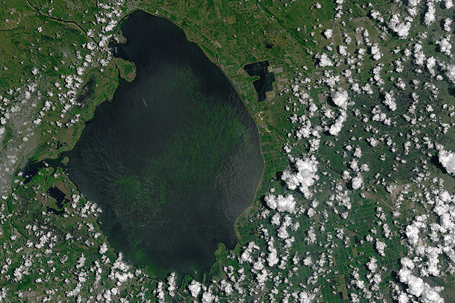
The image at the top of this story, showing Lake Okeechobee's bloom, was taken on July 2, 2016, by NASA’s Landsat 8 satellite, launched in 2013. Specifically, it used an instrument called the Operational Land Imager, which can take pictures in various wavelengths of light. In this case, the natural-color image combined red, green, and blue light.
While NASA has long used satellites to track ocean-based blooms, last year it partnered with the US Environmental Protection Agency (EPA), the National Oceanic and Atmospheric Administration, and the US Geological Survey to try something new: allow regular monitoring of the nation’s freshwater.
The idea is that early warning of a developing bloom would assist water treatment officials with their decisions as to when and how to treat water, avoiding costly and unnecessary over-treatment. It will also help with delivering accurate alerts to steer swimmers and boaters away from hazardous areas.
But the data will not be confined to those analyzing the satellites’ output. Instead, the plan is to roll out an app that receives regular updates, allowing officials to check the status of any given body of water with a glance at their phone.
“With our app, you can view water quality on the scale of the US, and zoom in to get near-real-time data for a local lake,” said the EPA’s Blake Schaeffer, principal investigator for the project. “When we start pushing this data to smartphone apps, we will have achieved something that’s never been done – provide water quality satellite data like weather data. People will be able to check the amount of ‘algae bloom’ like they would check the temperature.”


