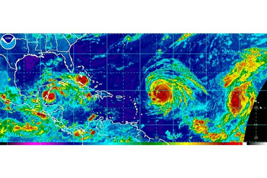
Hurricane Julia joins Igor in the Atlantic as Karl greets Mexico
Loading...
And Karl makes 11.
Tropical storm Karl made landfall in a remote area of the Yucatan peninsula early Wednesday.
Karl emerged from meteorological anonymity in the Caribbean during the afternoon of Sept. 14 to become the eleventh named storm of the 2010 Atlantic hurricane season.
When Karl finishes its Yucatan crossing and heads into the Bay of Campeche as a tropical depression, forecasters at the National Hurricane Center (NHC) in Miami say they expect the storm to strengthen and reach hurricane status by the time it makes landfall early Saturday morning.
Karl's track forecast – which still contains significant uncertainties in the storm's position on Saturday – puts landfall near the coastal city of Tuxpan, Mexico, which serves as headquarters for the Mexican Navy's Gulf fleet.
If the current intensity forecast holds, Karl will reach Category 1 status by then, with maximum sustained winds of about 86 miles an hour.
Karl stuck the Yucatan peninsula with maximum sustained winds of 65 miles an hour. So far, the region reportedly has experienced power failures and high winds. But for a patch of Mexican coast that reeled three years ago after a direct hit from Hurricane Dean, a monster storm at category 5, Karl has arrived as a relative whisper.
"There's a lot of wind," Violeta Pineda, a local hotel owner told the Associated Press. But the storm "is nothing in comparison" with Dean.
So far this year, Mexico's east coast and Texas' southern tip have served as the punching bags for tropical-cyclone activity in the Atlantic. Karl will be the fourth storm to make landfall there, compared with one hit for southern Florida from tropical storm Bonnie in July and hurricane Earl's flirtation with much of the US east coast in August. Earl finally made landfall on the southern tip of Nova Scotia as a tropical storm.
Even as forecasters keep an eye on Karl, they also are watching hurricanes Igor and Julia in the Atlantic. Both are category 4 storms with maximum sustained winds of 135 mils an hour.
In Igor's case, the latest wind measurements represent a slight weakening of the storm, which currently is located some 540 miles east northeast of the northern Leeward Islands and a little more than 1,000 miles southeast of Bermuda.
Forecasters at the NHC noted Tuesday that is was too early for Bermuda to worry much about the storm. On Wednesday, however, they say they expect the island to feel some "adverse conditions" from the storm. The current track has the center of Igor sweeping just to the east of the British territory on Sunday.
Large uncertainties remain in that track forecast as well, given the lead time involved. But forecasters add that Igor is a large storm, with tropical-storm force winds currently extending up to 225 miles from the storm's center. So even if the storm ultimately swings wide, strong winds still could buffet the island.
As for Julia, heading northwestward into the Atlantic nearly 600 miles west northwest of the Cape Verde Islands, the storm quickly strengthened in the past 24 hours to become the fourth major hurricane of the season. Julia is more compact than Igor, with tropical-storm force winds extending up to 115 miles from the center.
By Saturday morning, Julia is projected to be centered roughly 1,000 miles southeast of Bermuda and should begin to hook back toward the east as the storm weakens, forecasters say.


