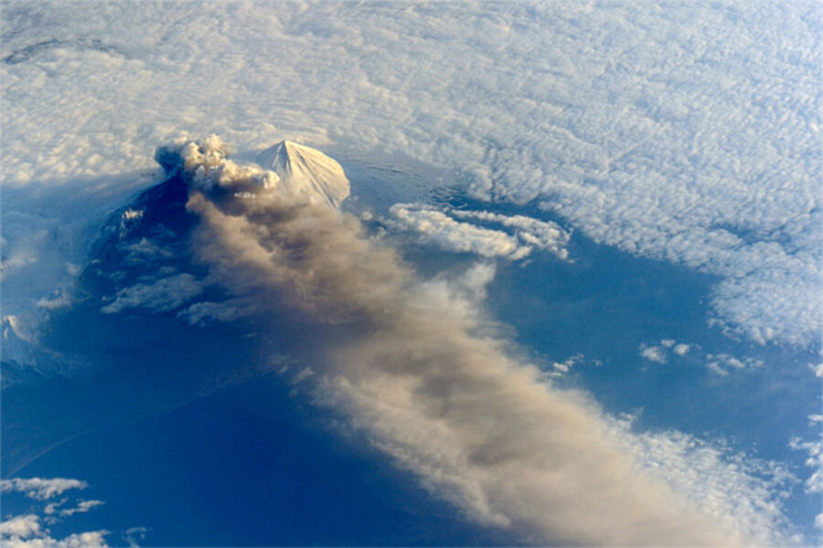
Space station astronauts snap amazing photos of Alaskan volcanic eruption
Loading...
Astronauts on the International Space Station captured jaw-dropping pictures of a volcanic eruption last Saturday. Since then, the volcano has been hidden from sight, shrouded in thick clouds.
Pavlof Volcano has been belching ash and spewing lava since May 13, when tremors and rising surface temperatures gave way to fountains of molten rock bursting from the volcano's north flank.
When that lava hit ice and snow, it created explosive steam clouds that could be seen for dozens of miles – and photographed from space. The steam, ash, and gas plumes have climbed over 20,000 feet into the sky, and left a grey streak stretching for a hundred miles.
Prior to last week, Pavlof hadn't erupted since 2007.
Is it over?
Pavlof has been playing it cool for the past few days, reports the Alaska Volcano Observatory, which celebrated its 25th anniversary last month.
Though the ash eruptions have disrupted local air travel, the violence seems to have subsided for now, with a more relaxed release of ash and lava continuing steadily. Even through the clouds hiding Pavlof from sight, satellites can measure high surface temperatures indicating that the lava is still flowing.
After about a week of steady seismic rumbles, the shaking calmed down on Tuesday morning and hasn't restarted, though a huge seismic blast this morning suggests that Pavlof had another volcanic explosion – but through the clouds, it's hard to know just what or where.
The scientists at Alaska Volcano Observatory have the volcano threat level set at "Watch," which is one step down from the highest level, "Warning." But they caution that massive explosions – like the one that created that giant, 20,000-foot plume – can occur without warning.
The Aleutian Islands are sparsely enough settled that the primary hazard from volcanoes like Pavlof is that airborne ash could endanger planes flying between North America and Asia. In fact, in 1989, a wide-body passenger jet encountered an ash plume from Redoubt, another Alaska volcano, and lost power in all four engines. Fortunately for the passengers, after the plane plummeted two miles in five minutes, the crew restarted the engines and landed safely in Anchorage, about a hundred miles away.
Why did Pavlof erupt?
Like the rest of the Aleutian Islands (and, for that matter, the Cascades), Pavlof sits on the boundary between the Pacific Plate and the North American plate. When the dense ocean floor runs into the less-dense continental crust, its weight pulls it down into the mantle, where the heat and pressures make it start to melt.
When rock melts, magma forms – and when magma reaches the earth's surface, it erupts as lava. The more water or gases were trapped in the magma, the more explosive the eruption will be.
Though scientists know exactly how volcanoes form, volcanologists can't yet predict eruptions. But they've made huge strides, thanks to regular monitoring of hundreds of active volcanoes around the world.
Volcano monitoring became a political punching bag in 2009, after Louisiana's Gov. Bobby Jindal highlighted it as "wasteful spending" in the Republican response to President Obama's State of the Union address. "Instead of monitoring volcanoes, what Congress should be monitoring is the eruption of spending in Washington, D.C.," said Mr. Jindal. The eruption of Redoubt Volcano a month later – the same volcano that had nearly crashed a passenger jet in 1989 – was seen by some as a definitive response, but video monitoring shrunk in recent years due to budget pressures and the sequester.
Alaska's 52 active volcanoes once had 200 working seismic instruments. Now 80 of those instruments have fallen into disrepair and can’t be fixed because of the USGS budget cuts, the Associated Press reported last week. That means that five of Alaska's 52 active volcanoes aren’t monitored electronically at all, and the number could rise if more instruments go without maintenance.


