Hurricane Arthur: Where is the storm headed?
By Thursday, tropical storm Arthur will likely have strong enough winds to be a Category 1 hurricane.
But if you're planning to watch fireworks or picnic on Friday July 4, that's a difference without much meaning. Either way, the East Coast is forecast to experience rain and high winds. How much rain or wind will depend how close Arthur comes to the coast.
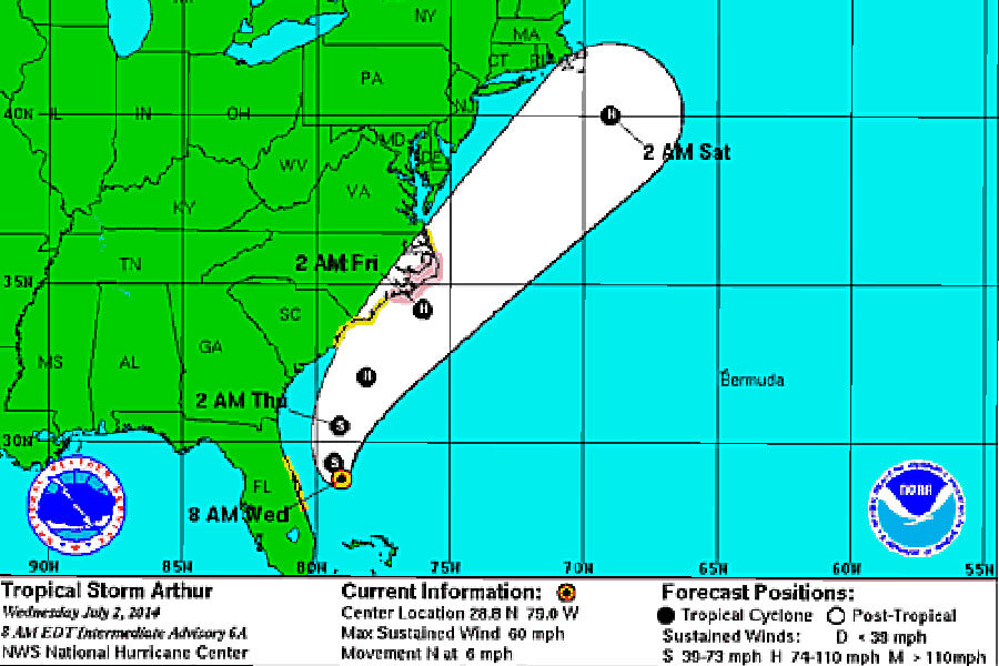
Current storm models show the eye of Arthur is going to brush the Carolinas before going northeast and away from land. None of the probable tracks show Arthur is expected to make landfall in New York or Boston, for example. But it's unclear still whether Arthur's winds and rain will disrupt the July 4th festivities of these cities.
As of 8 a.m. Wednesday, Boston's WBZ-TV meteorlogist Todd Gutner is forecasting a good likelihood of rain Friday afternoon and Friday evening, when the Boston Pops plays on the Esplanade and the traditional fireworks show follows.
I predict that the core of strongest winds will stay well south of the region but it cannot be ruled out that Cape Cod receives a spell of 20-40 mph northeast to northerly winds later Friday night into early Saturday. That is the period when the northwestern fringe of the envelope of rain from Arthur could stream over that area. With the passage of Arthur, larger waves will thrill the body and board surfers this weekend but dangerous rip currents will exist.
It could rain over Cape Cod into much of Friday night so festivities are destined to be dampened down there. Once Arthur accelerates beyond our longitude, refreshing air will be drawn over the region for another splendid weekend. Saturday will feature abundant sunshine and a brisk northwest to westerly wind with highs near 82. Sunday will be sunny with a warmup to near 88 with low humidity.
The Boston Globe reports that Boston city officials will make a decision about the fireworks show on Wednesday. "Mayor Martin J. Walsh and others did not rule out the possibility of moving the big event up a day; a preshow concert is already scheduled for Thursday. But forecasters said that Thursday could be worse than Friday, as the front threatened heavy rains and even flooding."
Currently, Arthur is still about 90 miles off the coast of Florida, moving at about six m.p.h, but is expected to accelerate as it gains strength and moves northward, according to the National Weather Service. Sustained winds are clocked at 60 m.p.h, and are forecast to peak at 85 m.p.h. in the next two days.
A hurricane watch is in effect for North Carolina from Bogue Inlet to Oregon inlet. And a tropical storm watch remains in effect for
the east coast of Florida from Sebastian Inlet to Flagler Beach and North Carolina. Rain fall totals are forecast in the 1-4 inch range.
Swimmers and surfers are warned, by the National Hurricane Center that heavy swells "are likely to cause life-threatening surf and rip currents, especially along piers and jetties. These hazardous conditions will gradually spread northward along the coasts of northeast Florida, Georgia, and South Carolina today."


