How a massive New Zealand earthquake broke the rules
Loading...
The earthquake that shook New Zealand in November didn’t just rip apart the landscape – it also toppled one of the fundamental tenets of earthquake forecasting.
"This was not your typical strike-slip earthquake," says Sigrun Hreinsdóttir, a geodetic scientist with New Zealand's GNS Science who took GPS measurements of the earthquake's movement. "The physics of it: How is the rupture capable of continuing so far, and 'jumping' between faults … and why does it then stop?"
While scientists have known that earthquakes can step from one fault to another, hopscotching across the terrain, some of the faults in the New Zealand earthquake were up to 10 miles apart. Until now, earthquake experts have taken as gospel that no quake can "jump" more than 3 miles (5 kilometers) to get from one fault to another.
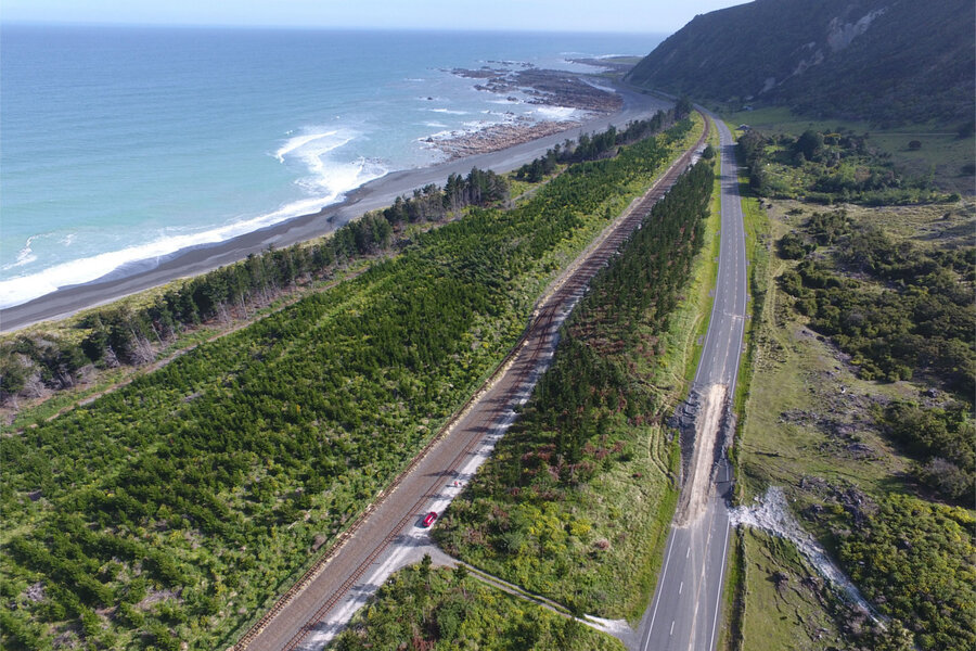
Four months ago, the magnitude 7.8 earthquake tore across the country for about three minutes, flinging land up and down by an eye-popping 20 feet, carving gashes across roads and fields, and turning beaches into cliffs. Since then, Kiwi scientists have documented that instead of moving along one simple fault, this earthquake ripped through "at least 12 major faults and many more smaller fault segments" as it traveled more than 100 miles up the New Zealand coast, says Ian Hamling, the lead author on the paper and a geophysicist with New Zealand's GNS Science, in a phone interview with The Christian Science Monitor.
In short, it's one of the most complex earthquakes in recorded history, say the scientists, who published their findings in the current issue of the journal Science. Even the theoretical models weren't prepared for something like this, they wrote:
"The exceptional rupture complexity during the Kaikōura earthquake, including apparent step overs of 15-20 km, would not have been considered as a plausible scenario in seismic hazard models."
Even the most sophisticated fault model in the world, designed in 2014, would not have allowed that "step over," explains Morgan Page of the United States Geological Survey's Working Group on California Earthquake Probabilities (WGCEP), one of the model's creators, who was not part of the New Zealand research. But it could have predicted the overall size and extent of the earthquake, she says.
"It's the only model of its kind anywhere in the world that does these kind of really complex ruptures," Dr. Page tells the Monitor.
She adds, "If anything, complex quakes like this one in New Zealand are the rule, not the exception."
After listing several other multi-fault earthquakes, including a 2002 quake in Alaska, one in Baja Mexico in 2010, and the 2012 "Earthquake in a Maze" in the Indian Ocean, she explains, "The analogy in California would be an earthquake that started on an unknown fault, went to the San Andreas, but then, after rupturing along the San Andreas for a while, veered off and took a turn onto some other fault."
But it's the size of the "turn" – the 10-mile space between two of the New Zealand faults – that really sets this temblor apart, the scientists agree.
And here's the twist: Despite appearances, this quake didn't truly "jump" the 10 miles. "Initially, it looked as if it jumped," explains Dr. Hamling, but his team has since discovered that the earthquake used an unknown, underground fault as a sort of secret passage to travel between two known faults.
That caught everyone by surprise. "New Zealand has one of the best active fault maps in the world, and still these faults we have no idea are there, can bridge this 5-kilometer limit," he says.
That will force a significant shift in hazard mapping, explains his colleague and coauthor Dr. Hreinsdóttir. "If you are evaluating risk in a region [with] multiple faults, you have to think about the possibility that they will rupture together, and there will be unknown faults that could connect the rupture," she tells the Monitor.
We can no longer say, " 'A 5-kilometer gap will stop it there,' " agrees Hamling. "If we have another fault in that area, that 5 kilometers becomes completely redundant."
To create accurate forecasts for insurance and building codes, the "rigidity" of the 5-kilometer upper limit "really needs to be removed from the models," he says.
Earthquake modeler Dr. Page agrees. "Now we have two examples – we have the Baja earthquake in Mexico in 2010, and we have this New Zealand earthquake where they ruptured more than 5 kilometers apart – so … we're going to have to figure out how to include this," she says.
But allowing for the unknown is inherently problematic, Page notes. "Do we just go in and draw linkages of faults we don't know about? Or do we just increase that rule to something bigger than 5 kilometers, and allow things to really jump?"
And the existing model already pushes limits of modern supercomputing, she adds.
"We're never going to know where all the faults are. It means we have to build our models in such a way that we allow for linkages between faults that are really far apart, assuming something could be there," Page says.
Because if a blind fault could hide underneath New Zealand, one of the best-fault-mapped areas in the world, it means the Earth has more surprises in store, says Hreinsdóttir.
"We had a very complex fault zone, resulting in a very complex earthquake," she says. "It showed us … what the Earth is capable of is really quite remarkable."


