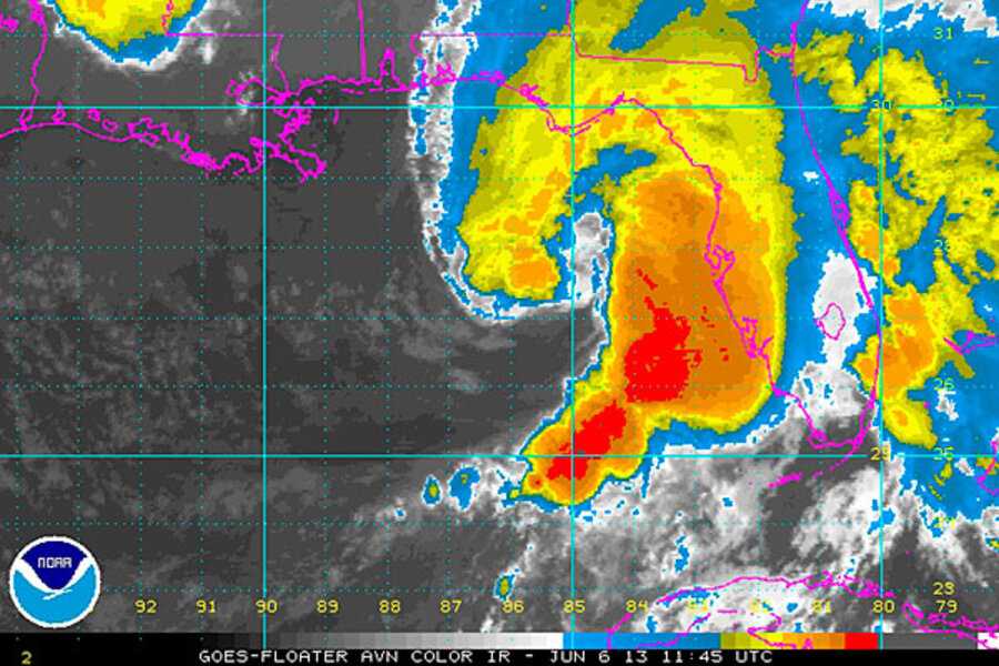
Tropical storm Andrea could soak entire East Coast
Tropical storm Andrea, the Atlantic hurricane season's first tropical cyclone, is moving on shore Thursday in the "big bend" area of Florida's west coast, after reaching tropical-storm status early Wednesday evening.
Once its center crosses northern Florida, the storm is projected to remain at tropical storm-strength as it spirals inland along the southeast coast before heading into the Atlantic near the southern tip of Chesapeake Bay.
Back over open water, Andrea is expected to lose its tropical characteristics, although it is forecast to bring heavy rain and strong winds to the East Coast before swinging east into the far North Atlantic Sunday.
As of 11 a.m. Eastern Daylight Time Thursday, the National Hurricane Center in Miami had posted tropical-storm warnings along Florida's west coast from Boca Grande to Indian Pass, while on the Atlantic side, warnings are up along a stretch of coast running from Florida's Flagler Beach to the lower Chesapeake Bay.
The warning means that tropical-storm conditions are expected within 36 hours.
The storm, currently centered about 112 miles west of Tampa, Fla., is moving northeast and packing maximum sustained winds near 60 miles an hour, with higher gusts. The tropical-storm-force winds extend up to 140 miles east of the storm's center.
The biggest risk from the storm as it tracks over Florida comes from inland flooding and tornadoes. So far, the National Weather Service's Storm Prediction Center in Norman, Okla., has received two reports of tornadoes in Florida: one in Pinellas County and the other in Broward County.
Forecasters at the the National Weather Service's Weather Prediction Center in College Park, Md., anticipate three-day average maximum rainfall totals along Andrea's path to range from 4 to 5 inches in northern Florida, southeastern Georgia, and South Carolina, to totals hovering in the 3- to 4-inch range all the way up to southern New England.
For some areas, such as Florida's west coast, those totals are likely to accumulate in one day. Elsewhere, the totals include rainfall from other storms. A key reason for providing forecasts of these cumulative totals, in addition daily forecasts, is to account for conditions that immediately precede the storm's arrival, says Brian Hurley, a lead forecaster at the Weather Prediction Center.
"A lot of times we see areas of rain gather strength well out ahead of the system," he says. Within the averages for given areas, "you know there would be the anticipation of higher totals in there."
Andrea began as a tropical disturbance in the Gulf of Mexico off the northeastern tip of the Yucatan Peninsula on Monday. Although the system formed on its own, it was able to tap leftover moisture from hurricane Barbara, an eastern Pacific tropical cyclone that fizzled over Mexico near the peninsula late last week, according to Jeff Masters, co-founder of the Weatherunderground.com website.
By Wednesday afternoon, the new system was swirling over the Gulf some 300 miles west of Key West. By 6 p.m. Eastern Daylight Time Wednesday, the system's maximum sustained winds had reached tropical-storm strength, prompting the National Hurricane Center to christen it Andrea.
Andrea's birthplace typically spawns season-opening tropical cyclones, Dr. Masters writes in his Weatherunderground blog. But on average these initial storms don't show up there until July 9. Still, for June storms, Andrea is taking one of two typical tracks. The other common track sweeps across the Yucatan Peninsula to make landfall somewhere along the Texas coast.


