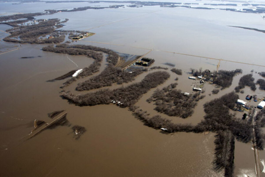
Red River floods fields, but US farmers ready
| WINNIPEG, Manitoba
Record flooding in parts of the U.S. Red River Valley has slowed grain movement, but lake-like fields are nothing new to farmers who battle flooding on some scale each spring, industry officials said.
The Red River, which divides North Dakota and Minnesota, is slowly easing from its Saturday crest at Fargo-Moorhead that left widespread flooding in fields north of the city.
Every year, farmers in the valley all but halt deliveries of stored crops to handling facilities due to muddy or flooded yards and roads, said Cory Tryan, grain department manager of Alton Grain Terminal at Hillsboro, North Dakota.
``It's normal, (farmers) make sure those bins are empty going into every spring,'' Tryan said. ``I don't think there's anyone caught with their pants down -- if there is, there shouldn't have been.''
No major breaches in Fargo-Moorhead's dikes have been reported, and the focus turned to rural communities that sit as islands within a series of lakes that have emerged.
Emergency crews used high-wheeled vehicles and airboats to reach residents.
``It's treacherous out there,'' said Captain Dan Murphy of the North Dakota National Guard.
Interstate 29, the highway that runs parallel to the Red River in North Dakota, was closed for more than 30 miles (48 km) from Fargo north to Hillsboro because of flooding.
A few weeks of warm weather, however, could allow farmers to resume grain and oilseed deliveries, Tryan said.
North Dakota has been the leading wheat-producing state the past two years and accounts for 16 percent of U.S. production. One-fifth of its crop usually comes from the Red River Valley.
Maple River Grain, based in Casselton, North Dakota, saw a surge of farmer deliveries in March before melting snow caused flooding, said general manager Sid Mauch.
``Most of the grain that would possibly be in jeopardy has already been moved,'' Mauch said.
FLOODING TO SLOW RAIL TRAFFIC, SUGAR BEET PLANTING
High levels on the Red River, which runs north from the United States into the Canadian province of Manitoba, will shut down a Canadian National rail line between Emerson, Manitoba, and Winnipeg later this week, allowing the province to erect dikes at some points on the rail line, said CN spokesman Warren Chandler.
CN runs one train daily in each direction on the line and will reroute traffic, he said.
Flooding could take up to 240,000 acres out of production this year if planting delays are severe, North Dakota's top agriculture official said on Friday.
Flooding has had little impact on processing of sugar beets at Minn-Dak Farmers Co-op's facility in Wahpeton, North Dakota, said spokesman Chris DeVries.
Farmers may not be able to start sugar beet planting for a couple of weeks due to wetness, he said.
North and South Dakota and Minnesota make up the United States' top sugar beet-producing region.
The Red River reached a crest of 38.75 feet on Saturday at Fargo, the fourth-highest on record, and should slowly recede to 36 feet by this Sunday, the U.S. National Weather Service said.
On Monday afternoon, the National Weather Service raised its projected crest for the Red River at Grand Forks, North Dakota, by 1.5 feet to 52 feet, which would be the second highest level on record after the 1997 flood.
The Red River crest is expected to reach Grand Forks from Thursday to Saturday at about the same time as peak flows from the Red Lake River tributary reach the river.
Flood walls built since 1997 are expected to leave Grand Forks with minimal damage this year.
No major rain is in the forecast for the next seven days in the Fargo area, U.S. forecaster Mike Palmerino of Telvent DTN weather service said on Monday.


