Malaysia Airlines Flight 370 was on autopilot when crashed, says official
Loading...
| Sydney
Malaysia Airlines Flight MH370 was most likely on autopilot when it crashed into the Indian Ocean further south than previously thought, Australian officials said on Thursday, as they charted the next phase of a so far fruitless search.
The new analysis comes more than 100 days after the Boeing 777, carrying 239 passengers and crew, disappeared on March 8 shortly after taking off from Kuala Lumpur bound for Beijing.
Investigators say what little evidence they have to work with suggests the plane was deliberately diverted thousands of kilometers from its scheduled route before eventually plunging into the Indian Ocean.
The search was narrowed in April after a series of acoustic pings thought to be from the plane's black box recorders were heard along a final arc where analysis of satellite data put its last location.
But a month later, officials conceded the wreckage was not in that concentrated area, some 1,600 km (1,000 miles) off the northwest coast of Australia, and the search area would have to be expanded.
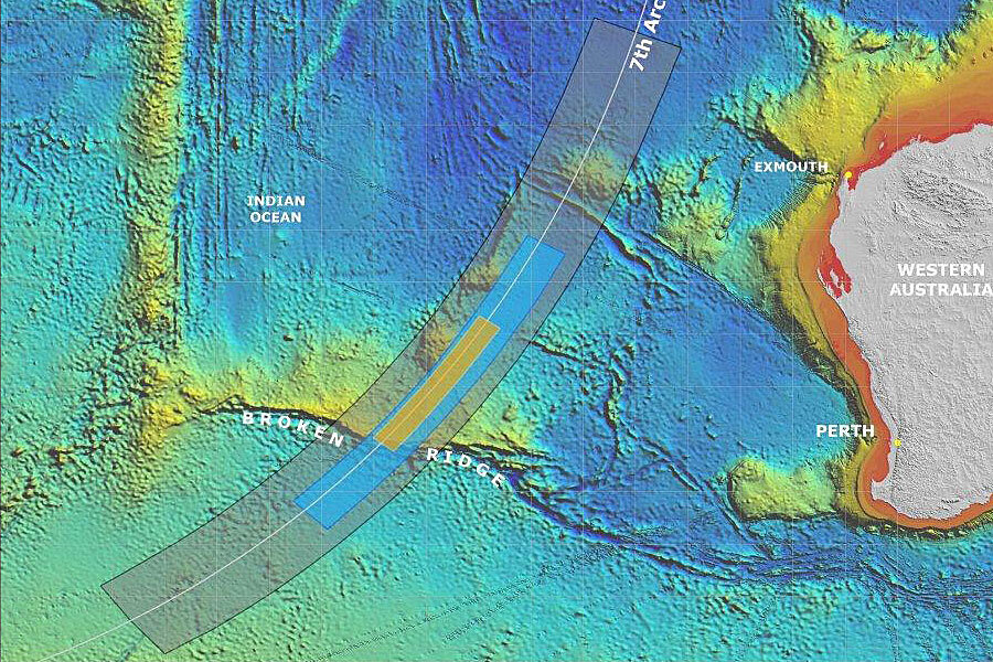
"The new priority area is still focused on the seventh arc, where the aircraft last communicated with satellite. We are now shifting our attention to an area further south along the arc," Australian Deputy Prime Minister Warren Truss told reporters in Canberra.
Truss said the area was determined after a review of satellite data, early radar information and aircraft performance limits after the plane diverted across the Malaysian peninsula and headed south into one of the remotest areas of the planet.
"It is highly, highly likely that the aircraft was on autopilot otherwise it could not have followed the orderly path that has been identified through the satellite sightings," Truss said.
The next phase of the search is expected to start in August and take a year, covering some 60,000 sq km at a cost of A$60 million ($56 million) or more. The search is already the most expensive in aviation history.
The new priority search area is around 2,000 km west of Perth, a stretch of isolated ocean frequently lashed by storm force winds and massive swells.
In a 55-page report, the Australian Transport Safety Board outlined a how investigators had narrowed down the possible final resting place from thousands of possible routes, while noting the absence of communications and the steady flight path.
"Given these observations, the final stages of the unresponsive crew/hypoxia event type appeared to best fit the available evidence for the final period of MH370's flight when it was heading in a generally southerly direction," the ATSB report said.
Two vessels, one Chinese and one from Dutch engineering company Fugro, are currently mapping the sea floor along the arc, where depths exceed 5,000 meters in parts.
Australia on Tuesday signed a contract with a private company to map the sea floor around where missing Malaysia Airlines MASM.KL Flight MH370 is believed to have crashed, a crucial step towards continuing an underwater search later this year.
The next phase of the search, which will be handed over from the military to the private sector, is expected to start in August and take up to a year, covering some 60,000 sq km (23,000 square miles) of ocean at a cost of A$60 million ($56.16 million) or more.
The search is already the most expensive in aviation history.
The Australian Transport Safety Bureau chose a subsidiary of Dutch multinational Fugro to perform the detailed underwater mapping necessary before that phase can begin.
"The bathymetric survey will provide a map of the underwater search zone, charting the contours, depths and composition of the sea floor in water depths up to 6,000 meters (3.7 miles)," Australia's Joint Agency Coordinating Center, which has been leading the multinational search, said in a statement.
"The survey will provide crucial information to help plan the deep water search for MH370 which is scheduled to commence in August."
(Additional reporting by Matt Siegel; Editing by Nick Macfie and Nick Macfie)


