How frigid 'polar vortex' could be result of global warming
The polar vortex putting the US in a deep freeze could represent how global warming is changing dynamics in the Arctic, researchers say. The current cold snap won't last long, though.

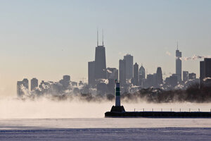
A blanket of fog covers Lake Michigan along the Chicago shoreline Monday as temperatures dove well below zero and wind chills were expected to reach 40 to 50 below. A whirlpool of frigid, dense air known as a 'polar vortex' descended Monday into much of the US.
Teresa Crawford/AP
A bitter Arctic blast spanning the central and eastern US has propelled the phrase "polar vortex" from the pages of dense scientific papers to headline status as frigid temperatures and strong winds close schools and businesses and prompt forecasters to warn of "historic and life-threatening" conditions.
In essence, a buildup of Arctic air, its chill deepened by 24 hours of darkness during winter, has breached its meteorological fence to pour deep into North America.
Such outbreaks often involve tendrils of cold air that can leak through the fence. This event, however, involves a large expanse of chilled air cleaved from an initial mass of cold air that can range from 600 to 1,200 miles across.
Paradoxically, the event may be a harbinger of winter outbreaks to come in the northern hemisphere as Earth's climate warms, some researchers say – a result of shrinking Arctic Ocean summer sea ice and the projected changes in wind and snowfall patterns triggered by the ocean's warmth and moisture.
It's been dubbed the warm-Arctic, cold-continent effect – one that doesn't show up well in seasonal forecast models but does appear in the real world, says Judah Cohen, director of seasonal forecasting at Atmospheric and Environmental Research (AER), a weather-risk management company based in Lexington, Mass. Climate models operating on longer time scales may be missing the effect as well, he adds.
At the heart of the issue is the polar vortex, a mass of cold air in the stratosphere that circulates counterclockwise over the Arctic and has a clockwise counterpart over Antarctica.
Deprived of sunlight during the winter, these vortices spin up, drawing energy from the temperature difference between the warmer air at mid-latitudes and polar air. The winds along the boundary form the polar jet stream. The sharper the temperature contrast, the stronger the jet stream and the better job it does keeping the cold air largely corralled at high latitudes.
But the jet stream doesn't flow in a nice, tight circle around the Arctic. Its interaction with different air masses and topography as it travels over oceans and continents forces the stream to meander north and south, as well as up and down by elevation.
Instabilities in the flow can allow the cold air to briefly migrate to lower latitudes. The vertical movement by elevation can allow weather systems from the lower atmosphere to drive a wedge into the vortex from below. Cold air in the gap between the two sections sinks and warms in events known as sudden stratospheric warming. Such events can cleave the entire vortex in two and allow a much larger mass of cold air to reach southward, according to atmospheric researchers Darren Waugh, at The Johns Hopkins University in Baltimore and Lorenzo Polvani of Columbia University in New York.
The flow has been relatively weak on average during the past six weeks or more. The current outbreak began with a warming event and with a weaker flow to hold back the cold, forecasters say.
The outbreak is likely to be short-lived. Dr. Cohen notes that an atmospheric blocking pattern over the eastern north Pacific has prevented warm, moisture-laden ocean air from moving east onto the continent.
"There's a pretty dramatic warmup coming," he says.
As for the future, he and other researchers have noted that such intense, short-term, regional chill-downs may occur more frequently as the climate warms the Arctic.
The change has been most obvious in the long-term decline of Arctic summer sea ice during the past 30 years. As the summer ice thins and shrinks in expanse, more ocean is exposed to longer hours of sunlight and absorbs heat that otherwise would have been reflected back to space. In the fall, heat and moisture return to the atmosphere with the moisture forming snow.
Working with seasonal forecast models, Cohen says he noticed that for the past four or five winters, preseason winter-temperature forecasts have been much too warm compared with the temperatures winter delivered.
In an initial experiment, Cohen and colleagues at AER and at Harvard University devised a statistical model for "forecasting" the winter of 2012-13 – marked by a warm Arctic and continents colder than official forecasts anticipated. The statistical model keyed off of fall snow cover in Eurasia as well as Arctic sea-ice extent in the fall.
Last September, the team reported that the statistical model yielded a warm Arctic, cold continent distribution of winter temperatures, while the official seasonal forecast models did not.
In the current forecast models, "you have a warm Arctic and warm continents. That warming over the Arctic kind of smears out across the continents as well."
In the real world, he adds, the relatively warm winter temperatures are confined to the Arctic.
"More work needs to be done," he acknowledges, but adds that the results suggested that season-forecast models and perhaps even long-term climate models are missing a distribution of wintertime temperatures important to forecasting regional climate on seasonal or longer time scales.

