Grand Ole Opry flood and other crazy weather: El Niño's fault?
Two major weather phenomena that emerged last year – El Niño and the North Atlantic Oscillation – put a big kink in the jet stream and caused blizzards, tornadoes, and perhaps even last weekend's torrent in Tennessee, which caused the Grand Ole Opry flood.

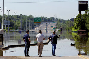
People look at the floodwaters on the grounds of the Grand Ole Opry House on Monday, in Nashville, Tenn., after heavy weekend rains and flooding.
Mark Humphrey/AP
The floods that have inundated Nashville, Tenn., nearly sank the Gaylord Opryland Hotel and the Grand Ole Opry, and killed at least 24 people may be part of a greater weather anomaly that has bedeviled parts of the South, Midwest, and Northeast since last fall.
The culprits? The famous El Niño warm-water effect in the Pacific Ocean sent moisture-soaked air up from the Gulf, even as a powerful phenomenon called the North Atlantic Oscillation put a linebacker block on the atmospheric jet stream off the East Coast, forcing Arctic air deep into the South. Tallahassee, Fla., broke its all-time cold record with 13 days straight of freezing temperatures in early January.
"Here's the story: The El Niño comes across, you get mudslides in California, snow in Dallas, tornadoes in areas you usually don't get them, and then as the low-pressure systems left the coast of the United States, the back side from the oscillation pulled all the cold air down," says Jim O'Brien, an El Niño expert at Florida State University in Tallahassee. "It's the ocean, baby."
IN PICTURES: Nashville Flooding
Last year's historic Atlanta floods, early snowfall in the South, a triad of blizzards striking Washington, D.C., bone-chilling temperatures that produced snow in Florida and freeze-shocked sea turtles by the hundreds, and deadly spring tornadoes in Mississippi and Alabama all can be attributed to the two phenomena working in tandem.
The two heighten the intensity of otherwise routine events. The Nasvhile area experienced what the US Army Corps of Engineers called a "1,000-year event" this weekend, when it nearly doubled its daily rainfall record, as 13 inches of rain fell in 24 hours. Indeed, weather-watchers had warned in March of high probability of flooding this spring.
The deluge caused the Cumberland River to crest, sending sewage-ridden water bursting into the Music City's neon-lit tourist district. The Predators hockey team's locker rooms were washed out, and a fallen Elvis wax statue lay near the Opryland Hotel, where an immense indoor park was under water, with tables and chairs floating around, according to the Associated Press. The storm claimed victims, young and old, who did not escape the water in time.
Climate interpreters, however, aren't so ready to link the Tennessee floods to the El Niño-oscillation confluence.
"The general conditions in the Ohio Valley have been dry, and that dryness is consistent with what we typically see during El Niño years," says Martin Hoerling, a climate specialist at the National Atmospheric and Oceanic Administration. "So you might say this is inconsistent with what El Niño might otherwise do. There are many things that can cause extreme events, but there's not always a single cause."
Now for the capper: How does global warming – or cooling for that matter – play into this crazy weather year?
"[The] globe is warming. But the real story behind the mid-Atlantic’s winter isn’t about climate change, it’s about climate variability," reads a recent NOAA report. "Climate variability … explains why record-breaking snowstorms and global warming can coexist. In fact, many of the weather events observed this winter help to confirm our understanding of the climate system, including links between weather and climate."
Thankfully for many Americans (as well as winter-weary Europeans), that variability is likely to calm down. El Niño is expiring and will be done by June. Its partner, the North Atlantic Oscillation, has mostly spun itself out, as well.
Related:
