Winter storm Hercules sweeps out, leaving Northeast with loads to shovel
Winter storm Hercules packed more punch than had been expected. Before the storm exited the Northeast by midday Friday, parts of Massachusetts were coated in almost two feet of snow, and air travel was disrupted at the region's major airports.

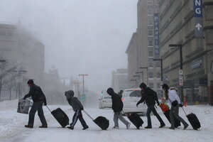
Winter storm Hercules made the trek tough for travelers leaving a train and subway station in Boston on Jan. 3. Some parts of Massachusetts had accumulated almost two feet of snow as of Friday morning.
Brian Snyder /Reuters
Boston
A storm of herculean strength that unfurled across the Northeast Thursday night and into Friday morning dropped snowfall in many areas that exceeded forecasters' predictions and sent temperatures plunging to bitter lows.
In a dramatic, if frosty, welcome to 2014, the winter storm, dubbed Hercules, reached its apex overnight Thursday, dumping almost two feet of snow on parts of Massachusetts by Friday and causing parts of upstate New York to shiver in wind chills that notched in the minus 30s. The storm, which has had much of the mid-Atlantic and New England in a de facto hibernation since Thursday morning, scuttled travel plans, thwarted commuters, and prompted school closures around the region on Friday morning.
Eastern Massachusetts had the highest snowfalls as of Friday morning, with the towns of Topsfield and Boxford each accumulating more than 23 inches of snow, according to the National Weather Service.
A winter storm warning lasted in Massachusetts until 10 a.m. Friday, and the hard-hit eastern portions of the state were also under blizzard warnings, meaning that visibility will be at less than a quarter-mile for at least three hours. The National Guard is on standby to assist along the state's coast, where storm surges of more than two feet are likely in some areas.
Boston, while not under a blizzard warning, is expected to accumulate about 14 inches of snow by Friday evening, at least four inches more than had been forecast one day ago. Jan. 2 was a calendar-day snowfall record for the city, with snowfall reaching 10.6 inches, a total not seen on that date since 1906, the National Weather Service said. All public schools are closed, and a parking ban is in effect while some 500 plows fan through the streets.
Temperatures in Boston hovered in the single digits Friday morning, but winds of about 30 miles per hour are expected to put wind chills as low as 22 degrees F. below zero. The entire state is under a winter chill advisory until Saturday morning.
In New York, Gov. Andrew Cuomo declared a statewide state of emergency at about 3:45 p.m. Thursday and, via Twitter, asked residents to “stay off the road if you can.” The measure included closing several major highways until Friday morning, including portions of Interstate 84 and the Long Island Expressway between Nassau County and New York’s Queens borough.
In upstate New York, wind chills are expected to remain between -30 and -40 degrees until Saturday morning, the National Weather Service said. And in New York City, where all public schools are closed, parts of the Bronx piled up about eight inches of snow and Central Park was swaddled in about half a foot of the white stuff. Mayor Bill de Blasio, inaugurated Wednesday, said 2,500 plows were on the streets as of Thursday morning, and city residents could track the plows' progress through their neighborhoods on NYC.gov.
In Connecticut, winter storm warnings were in effect for most of the state until Friday morning, and high winds put temperatures at about 20 below zero in parts of the state. In New Jersey, Gov. Chris Christie declared a state of emergency on Friday, closing state offices, and on Twitter he asked travelers to keep off the roads to keep the way clear for first responders.
Parts of Rhode Island and New Hampshire received more than half a foot of snow, and Chicago was coated in about 12 inches of snow.
Travel was disrupted across the country on Friday because of the storm, with some 1,602 flights canceled and another 640 flights delayed, according to FlightAware. Major airline hubs – JFK International Airport in New York and Logan International in Boston – were both closed Friday morning. Amtrak between Boston and Washington, D.C., and Metro North were running with reduced schedules, and Greyhound bus service was either canceled or delayed between stops in Boston, Maine, New York, and Vermont.
In coming days, the Northeast will experience some “weather whiplash,” with temperatures rising only to plummet again, said a spokesman for the National Weather Service.
The storm’s snowfall should taper off in the Northeast by Friday afternoon, but temperatures will remain frigid, keeping much of the region in the teens and single digits. On Monday, temperatures will rise as high as the mid-40s, and another storm swirling through the area will bring rain. On Tuesday, temperatures will take “another plunge into the icebox,” with wind chills in the negatives, as the region gets smacked with Arctic air, the National Weather Service spokesman said.
The Northeast’s most extreme snowstorm on record was in March 1993. That storm swathed most of the region in between 10 and 20 inches of snow, with some areas racking up more than 30 inches.

